Flow is monitored throughout the basin at various hydrometric monitoring stations that are also used to monitor water quality and many other parameters important to our understanding and conservation of river resources.
The existing gauging network in the Orange-Senqu River Basin is shown in map below. As indicated, the density of the monitoring network is greatest in areas of highest runoff production. Many of the longest records are also found in these areas.
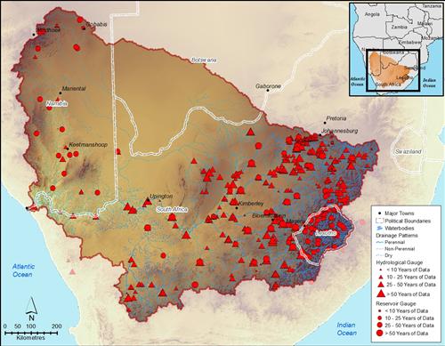
Gauging stations in the Orange-Senqu River Basin
Source:ORASECOM 2011
( click to enlarge )
The Department of Water Affairs (DWA) in South Africa maintains an up-to-date on line database of flow information for monitoring stations found within South Africa and Lesotho. The figure below was developed from this DWA dataset and shows flow in mm/year over time for the Upper Vaal, Upper Orange-Senqu and Lower Orange Rivers.
Preciptation and evaporation are measured in millimeters per year (mm/year), a unit of runoff that is normalized over the watershed (basin) area. Use of this parameter allows data from hydrometric monitoring stations in different watershed areas to be compared with flow.
The graphs below illustrate inter-basin flow variability over the years. Looking at these graphs, it is clear that the Upper Orange-Senqu River contributes the highest flow in the basin; the Vaal River contributes a relatively lower amount of flow; and, at the downstream portion of the basin near the mouth there is no flow in some years.
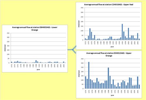
Annual flow monitored at hydrographic stations.
Source:DWA South Africa 2009
( click to enlarge )
SADC-Hydrological Cycle Observing System (HYCOS)
In addition to the flow monitoring undertaken by the national departments of water, there are monitoring stations in the Orange-Senqu River basin that contribute to the SADC-HYCOS. SADC-HYCOS is a regional component of the global World Meteorological Organisation initiative. It is implemented within the context of the SADC Regional Strategy Action Plan on Integrated Water Resources Management (RSAP-IWRM) (SADC-HYCOS 2009). The South African Department of Water Affairs, (Pretoria, South Africa) is hosting the Pilot Regional Centre (PRC), with technical and financial assistance from the Centre for Ecology and Hydrology (CEH), in Wallingford, UK (European Union 2002). The purpose of the project is to enhance and coordinate hydro-meteorological monitoring in the region, and develop an operational integrated regional water resources database and website.
Box: Objectives of the SADC-HYCOS Monitoring Programme.
-
Provide SADC with one of the necessary operational tools (information system) for the sustainable improvement of regional integrated water resourcses assessment, monitoring and management for a peaceful and sustainable development of the region;
-
Assist the participating countries in developing their own national capacity in these fields to allow them to fully participate in and benefit from the project; and,
-
Collaborate with other national, regional and international projects and programmes, towards the modernisation, rationalisation and improvement of the efficiency, cost-effectiveness and sustainability of the water resources and related fields information systems in the continental part ofthe SADC region and at the international level.
Source: SADC-HYCOS 2009
The following map shows locations of SADC HYCOS monitoring stations (Phases 1 and 2) across the Orange-Senqu River basin. SADC-HYCOS is implemented in close collaboration with the National Hydrological Systems (NHSs) and with the World Meteorological organisation (WMO).
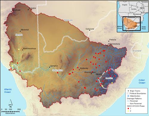
SADC HYCOS Stations in the Orange-Senqu River Basin.
Source:ORASECOM 2011
( click to enlarge )
For more information, please visit the SADC-HYCOS website.
Further Reading:
ORASECOM 2011. Improvements of Gauging Networks and Review of Existing Data Aquisition Systems.