
Maps are for display purposes only and must not be used for navigation
Page 1 of 4 next »
Longitudinal profile of the main-stem of the Orange-Senqu River. Source:Hatfield 2009 ( click to enlarge ) |
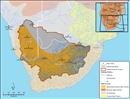
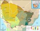
 Dominant landforms of the Orange-Senqu River basin. Source:FAO 2003 ( click to enlarge ) |
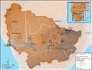
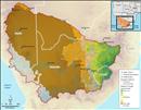
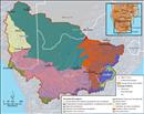 Terrestrial Ecoregions of the Orange-Senqu River basin. Source:WWF 2004 ( click to enlarge ) |
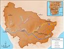
 Geomorphological Provinces of southern Africa. Source:After Bridges,1990 ( click to enlarge ) |
 The Great Escarpment of southern Africa. Source:After Bridges,1990 ( click to enlarge ) |
 Legend map for river profiles. Source:Hatfield 2009 ( click to enlarge ) |
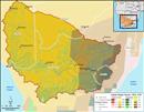
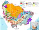 Generalised surface lithology map of the Orange-Senqu River basin. Source:SADC 2010 ( click to enlarge ) |
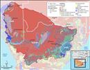
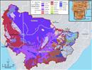 Soil map of the Orange-Senqu River basin (no data for Lesotho) Source:ISRIC World Soil Information Database 2003 ( click to enlarge ) |
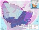 Soil erosion severity across the Orange-Senqu River basin. Source:Oldeman, Hakkeling and Sombroek (1990) ( click to enlarge ) |
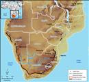
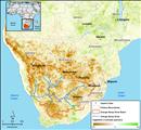
 The distribution of mines across the Orange-Senqu River basin. Source:Hatfield 2009, after UNDP 2008 ( click to enlarge ) |
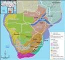
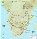 The International Basins of Southern Africa. Source:Hatfield, 2010 ( click to enlarge ) |
 Water scarcity in southern Africa. Source:Hatfield 2009, after World Water Assessment Programme 2009 ( click to enlarge ) |
 Satellite-based measurements of vegetation as an indicator of drought from 2007 (see description below). Source:NASA GIMMS Group at Goddard Space Flight Center 2007 ( click to enlarge ) |
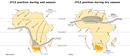 Inter-Tropical Convergence Zone (ITCZ) variation across Africa throughout the year. Source:Ker et al. 1978 ( click to enlarge ) |
 Precipitation across the Orange-Senqu River basin. Source:Hatfield 2009, after UNDP 2008 ( click to enlarge ) |
 Evapotranspiration across the Orange-Senqu River basin. Source:Hatfield 2009, after UNDP 2008 ( click to enlarge ) |
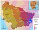
 Köppen classes for climate in the Orange-Senqu River basin. Source:Kottek et al. 2006 ( click to enlarge ) |
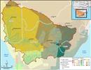
 Retrospective Köppen-Gieger Climate Classification for the Orange-Senqu River basin (1901 - 1925). Source:Rubel and Kottek 2010 ( click to enlarge ) |
 Projected Köppen-Gieger Climate Classification for the Limpopo River basin (2076 - 2100). Source:Rubel and Kottek 2010 ( click to enlarge ) |
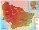
 Relative Drought Hazard Index for the Orange-Senqu River basin. Source:Leira et al. 2002 ( click to enlarge ) |
Page 1 of 4 next »