In southern Africa, groundwater is a critical resource because of its limited availability and the variable quality of surface water resources (UNEP 2009). Groundwater accounts for approximately 30 % of all freshwater on Earth and 94 % of all available freshwater (freshwater not stored in glaciers and ice-sheets) (Ward and Robinson 2000). The table below shows the contribution of groundwater to freshwater systems, the hydrologic cycle and drinking water.
Table: Contribution of groundwater to freshwater systems and the hydrologic cycle.
|
Water source
|
Water volume (km³)
|
Percent of total water
|
|
Oceans
|
1 338 000 000
|
96,50 %
|
|
Ice caps, Glaciers, & Permanent Snow
|
24 064 000
|
1,74 %
|
|
Groundwater
|
23 400 000
|
1,7 %
|
|
Fresh
|
10 530 000
|
0,76 %
|
|
Saline
|
12 870 000
|
0,94 %
|
|
Soil Moisture
|
16 500
|
0,001 %
|
|
Ground Ice & Permafrost
|
300 000
|
0,022 %
|
|
Lakes
|
176 400
|
0,013 %
|
|
Fresh
|
91 000
|
00,07 %
|
|
Saline
|
85 400
|
0,006 %
|
|
Atmosphere
|
12 900
|
0,001 %
|
|
Swamp water
|
11 470
|
0,008 %
|
|
Rivers
|
2 120
|
0,0002 %
|
|
Biological water
|
1 120
|
0,0001 %
|
|
Total water volume
|
1 385 984 510
|
100 %
|
Source: USGS 2005.
Increased demand for water worldwide has led to unsustainable exploitation of groundwater resources. Where increased demand has stressed or exhausted surface water resources, national and regional authorities have increasingly turned to groundwater as a solution.
Groundwater is found in sub-surface geological formations called aquifers. Aquifers are usually defined as layers of hard rock or unconsolidated deposits that can hold significant amounts of water (Ward and Robinson 2000). Freeze & Cherry (1979) apply the term aquifer only to formations that contain economic quantities of water.
There are two types of aquifers:
-
Primary aquifer occurs in unconsolidated deposits. They have primary porosity, which means the water held in spaces between granules in the rock;
-
Secondary aquifer occurs in hard rock. The water is not absorbed into the rock, but held in spaces (fractures, fissures and faults) between bodies of impermeable stone (Spitz and Moreno 1996).
The level of water in a body of rock is known as the water table. In a primary aquifer, this is a physical level in the rock, up to which water is present. In a secondary aquifer, the water table is an abstract representation of the amount of water held in the spaces between the rocks.
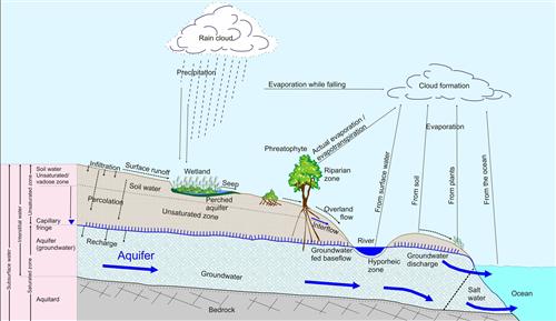
The diagram below illustrates the role of groundwater in the hydrologic cycle.

The Role of Groundwater in the Hydrologic Cycle.
Source:CSIR 2004
( click to enlarge )
In a confined aquifer, an impermeable and unfractured rock blocks the water from flowing into the aquifer from above. Confined aquifers are recharged by groundwater flowing in laterally from adjacent areas. An unconfined aquifer is not is not restricted by an impermeable layer, and can be recharged by water percolating down from the soil.
Groundwater is a renewable resource; replenished or recharged when rainfall is absorbed through the soil and percolated down to aquifers. Groundwater recharge occurs by:
-
Infiltration of precipitation through the ground
-
Lake and river water seepage through the beds and the banks
-
Leakage from adjacent groundwater sources
-
Artificial recharge from irrigation, pipeline leakage, direct injection, etc
Groundwater discharge occurs by:
-
Evaporation from a high water table near the surface
-
Seepage into surface water bodies or spring flow
-
Seepage into adjacent groundwater sources
-
Artificial abstraction
To be available for supply, groundwater has to be continually recharged. Groundwater is usually recharged by rainfall and streamflow. The recharge process and rate depend on the nature of the aquifer, which determines its ability to receive and store groundwater, and the movement of water within the aquifer.
If the rate of groundwater extraction (sometimes called abstraction) is higher than the rate of recharge, the resource will dwindle and become exhausted. Unsustainable groundwater extraction can lead to the collapse of an aquifer.
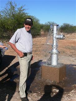
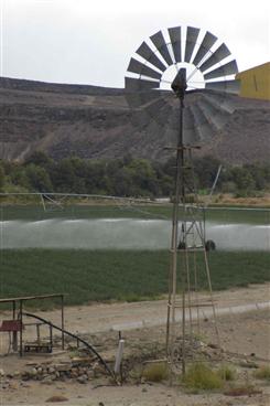
Groundwater is extracted through wells or boreholes (Rebouças 2004). Wells are drilled through the soil layer, down into the rock until they meet the water table. Boreholes are drilled using a truck-mounted drilling rig. Sometimes, groundwater is held under pressure by a confining layer; when a drill penetrates the aquifer, water is released under pressure. This is known as an artesian aquifer or well.
 An artesian borehole in the Stampriet area of Southern Namibia. Source:Kirchner 2008 ( click to enlarge ) |
 A wind-pump attached to a borehole in the Lower Orange River region. Source:Vogel 2009 ( click to enlarge ) |
Siting of boreholes depends on the geology of an area. Hydrogeologists estimate where water may be found using geological maps, aerial photography and satellite images, combined with an understanding of the type of rock and the way it was formed. In southern Africa, hydrogeologists identify zones of high probability of reaching groundwater using geological fractures and faults. In addition, knowledge of geomorphology and an understanding of the local and regional groundwater environment is used to identify potential drill locations (Hughes 2005). In drier environments, the presence of vegetation can also indicate groundwater.
