Overview
Weather forecasts and climate change projections are made by applying Global Circulation Models (GCM). These mathematical models work by simulating the large-scale circulation of the atmosphere, biosphere and ocean currents, measuring variables such as temperature, precipitation, vegetation and sea-level, which are all factors that influence climate.
For these projections to be as accurate as possible, scenarios surrounding the amount of greenhouses gas emmisions anticipated need to be formulated and fed into the model. In general, scenarios are divided into four 'families' covering those that refer to a economically driven future and those that take into serious account environmental issues.
The table below provides a brief summary of the scenario families.
Table 1: Global Circulation Model Scenario Families
|
A - ecomically driven future |
B - environmental issues key |
|
1 |
2 |
1 |
2 |
|
Describes a future world of very rapid economic growth, global population that
peaks in mid-century and declines thereafter, and the rapid introduction of new and more efficient technologies.
|
Describes a heteregenous world of self-reliance and
preservation of local identities. Fertility patterns across regions converge very slowly. Economic development is primarily regionally oriented. per capita economic growth
and technological change are more fragmented and slow.
|
Describes a convergant world with rapid changes in economic structures toward a service
and information economy, with reductions in material intensity, and the introduction of clean and resource-efficient
technologies.
|
Descibes a world in which emphasis
is on local solutions to economic, social,
and environmental sustainability.
|
|
Themes: convergence,capacity & social development. |
Themes: continous increasing global population. |
Themes: environmental sustainabiliy, improved equity. |
Themes: environmental protection,
social equity at local levels.
|
The aim of Downscaling is to translate the large -scale coarse projections of the GCM to finer mesoscale resolutions that will be useful for understanding the influence of climate change at regional scale.Downscaling allows for all other relevant features of the region (including land use patterns,orography and vegetation) to be incorporated into the model resulting in information that is more reliable and useful for assesing impacts. Approaches to downscaling are categorised into two models, dynamic and statistictical.
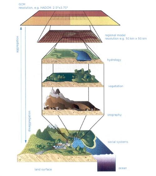
Downscaling: coarse resolution to a finely grained model.
Source:ORASECOM 2010
( click to enlarge )
Down-Scaling for the Orange-Senqu
In February 2011, the results of a climate projection experiment conducted by the Potsdam Institute for Climate Impact Research (PIK) for the Orange-Senqu River basin were accepted by ORASECOM.This experiment was performed with the use of two complementary approaches: the Cosmo-CLM (CCLM) model (dynamic approach) and the Statistical Regional (STAR) model (statistical approach) (ORASECOM 2011).
Using scenarios from the A1 family (see table above), the following steps were followed to develop further scenarios for climate change in the region, for the period 2011 to 2060;
Step I: - Preparation: Review and Data Re-processing
-
Establishing of the climate database;
-
Analysis of recent climatic changes;
-
Review of relevant global change studies; and
-
Compilation of the spatial data base.
Step II - Exploration: Model Adaptation and Validation
-
Exploring climate models STAR II and CCLM for regional conditions.
Step III - Application: Model Application for Scenario Development and Regionalisation
-
Calculation of climate change scenarios
The applicability of the models for the basin was tested using similair time periods and relavant variables. Results, after verification, showed that in most cases the CCLM simulation did not produce reliable precipitation data, this was especially the case because most water in the basin is run-off from Lesotho as opposed to rainfall.This model still needs to be improved for the region.
The STAR simulation provided more reliable future projections of temperature and precipitation when compared with past observations. Results from this model showed a projected increase in temperature (by over 2°C) and decreased precipation spread evenly across the basin. It is recommended that this model is used for future climate projections in the region.
Impacts & Adaptation Strategies
From the projections of increased temperatures and lower precipitation predicted by the downscaling processs, it is believed the region will experience the following impacts (Orasecom 2011):
-
Reduced productivity & viability of farming (especially the rain-fed agriculture of Lesotho)
-
Soil erosion
-
Higher crop water requirement,
-
Double-cropping,
-
Reduced groundwater recharge,
There are a range of potential adaptation measures to be considered for the rain-fed sector:
-
Genetic measures (new drought tolerant/high-yielding varieties);
-
Land reclamation measures (to increase soil water holding capacity – manure, increase in organic matter, etc);
-
Agricultural practices (soil and water conservation, soil cultivation – reduced tillage, water harvesting, mulching, etc);
-
Supplementary irrigation; and
-
Knowledge, awareness, education and capacity building.
Further downscaling exercises for more reliable results in the region is advised, taking care to improve all data collection efforts for more accurate input data across the basin, as well improving the river gauging network.
The
ORASECOM IWRM
climate change downscaling reports can be found in the
Document Library.