An Ecological State of the Orange-Senqu River basin report for 2003-2008 has been compiled by the Institute of Natural Resources (INR) at the University of KwaZulu Natal. This is intended to provide a baseline that can be used by ORASECOM to "Develop and agree on an assessment tool and sites for determining transboundary aquatic ecosystem health". The overall project is funded by the European Union and INR was appointed on behalf of SADC and ORASECOM (ORASECOM 2009).
This report assesses the health of each ecoregion in the basin by compiling results from invertebrate, fish and vegetation monitoring programmes that have already been conducted in the basin. Invertebrates are used as the primary indicator of the health assessment as they are used internationally as indicators of water quality, specifically with regard to pollution, organic enrichment, water abstraction (flows) and acidification. The distribution, types, species and abundance of invertebrates provide clues regarding the overall health of the environment in which they are found.
Eastern Escarpment Mountains Ecoregion
Invertebrate monitoring during the Lesotho Highlands Water Project indicated that most areas were in reasonable condition with the exception of an area immediately below Katse Dam, which was considered a stressed area. The condition of the fish monitored was generally better than expected and riparian vegetation met targets set by the Lesotho Highlands Development Authority.
Indicators of stress include salinity, nutrients, sediment loading, turbidity and riparian vegetation disturbance. Of these indicators, sedimentation is the the largest source of stress and has resulted in the Welbedacht Dam in South Africa losing 80-90% of its storage capacity.
Highveld Ecoregions
Because sites in this ecoregion have been altered extensively it is difficult to assess the overall health of the area due to the lack of reference conditions. All sites monitored in this area are ranked as stressed to extremely stressed. There are contradictory studies that rank some areas as being natural; however, this is not the case.
Stress in the highveld ecoregions includes discharges from industries, mine dewatering, wastewater treatment works, irrigation return flows and runoff from developed areas.
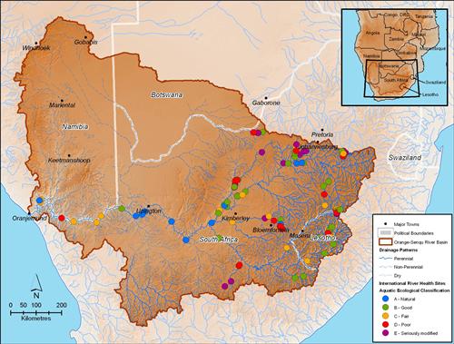
Draft Aquatic Ecosystem Health Map (2003-2008) for the Orange-Senqu River basin.
Source:Hatfield 2009, after ORASECOM 2009
( click to enlarge )
Southern and Central Kalahari Ecoregions
The biota of the Vaal River below Bloemhof Dam indicate some stress while the biota in the Harts River is much more stressed. Lower parts of the Vaal and sites around the town of Taung also indicate stress, in some cases severe.
Water quality in the Vaal, Harts and Modder Rivers is a sources of stress, including problems with salinity, nutrients, acidity and toxins.
Nama Karoo Ecoregion
With the exception of the reach immediately below Vanderkloof Dam, this area is considered to be in good condition. A full assessment is limited by the fact that there are only a few monitoring sites in this region. A more comprehensive assessment would require more monitoring sites.
Salinity in the Riet River is the main source of stress in this region, along with channel modification associated with the Gariep and Vanderkloof Dams. The temperature regime changes as a result of these dams has also been indicated as a source of stress.
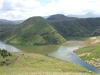 Despite the significant pressures from developments in the basin, the rivers of the Orange-Senqu River system host rich aquatic communities. Source:Lesotho Water Commission 2002 ( click to enlarge ) |
Orange River Gorge Ecoregion
As with the Highveld Ecoregions there are very few, if any, reference areas in this ecoregion; therefore, the confidence of assessment is low. Most sites indicated fairly stressed conditions with the site above Vioolsdrift in poor condition. Poor water quality and a lack of habitat diversity for invertebrates are considered major reasons that the assessments deemed this habitat as stressed.
Salinity is the major water quality factor in this area, and flow regulation is another source of stress. A recent survey on riparian vegetation from Augrabies to the River Mouth indicated that most has been altered.
Limitations
The method used to interpret invertebrate data and assign a state of health to each area is based on the method of Dallas 2007. This method is currently only in draft form and includes two weaknesses, which may affect its usefulness for the Orange-Senqu River basin. Firstly, the sites in the Lower Orange may be skewed to the negative because there is no site that is severely polluted (and there are a limited number of sites); and secondly, the opposite occurs in the Highveld where there are no pristine sites in the analysis resulting in skewing to the positive.