There are 15 recognised transboundary river basins in the Southern African Development Community (SADC) region. They range in size from the large Congo River Basin (3 730 470 km²) in the northern part of SADC, to Umbeluzi River Basin (5 500 km²) in the southeast. The Zambezi River Basin (1 390 000 km²) covers eight SADC member states. It is estimated that about 70 % of the water resources in the SADC region are shared by more than one country. Thus one of the characteristic features in the region, is shared watercourse systems, with complex water rights and potential conflicts over utilisation of the shared resources (SADC 2005).
The table below lists the river basins, selected river charateristcs (basin area, river length and mean annual runoff [MAR]) and the riparian states that they include.
Transboundary River Basins in SADC.
|
River
|
Basin Area (km²)
|
RiverLength (km)
|
MAR
(Mm³)
|
Riparian States
|
|
Buzi
|
31 000
|
250
|
2,5
|
Zimbabwe, Mozambique
|
|
Congo
|
3 730 470
|
4 700
|
1 260 000
|
Angola, Burundi, Rwanda, Central African Republic, Tanzania, Congo,
Cameroon, DR Congo, Zambia
|
|
Cuvelai
|
100 000
|
430
|
Ephemeral
|
Angola, Namibia
|
|
Incomati
|
49 965
|
480
|
3,5
|
South Africa, Swaziland, Mozambique
|
|
Kunene
|
106 500
|
1 050
|
5,5
|
Angola, Namibia
|
|
Limpopo
|
408 000
|
1 750
|
5,5
|
Botswana, South Africa,
Zimbabwe, Mozambique
|
|
Maputo-Usutu-Pongola
|
32 000
|
380
|
2,5
|
South Africa, Swaziland, Mozambique
|
|
Nile
|
3 254 555
|
6 700
|
86
|
Tanzania, Burundi, Rwanda,
Kenya, Uganda, D R Congo,
Eritrea, Ethiopia, Sudan, Egypt
|
|
Okavango
|
530 000
|
1 100
|
11
|
Angola, Namibia,
Zimbabwe, Botswana
|
|
Orange-Senqu
|
721 000
|
2 300
|
11,5
|
Lesotho, South Africa,
Bostwana, Namibia
|
|
Pungwe
|
32 500
|
300
|
3
|
Zimbabwe, Mozambique
|
|
Ruvuma
|
155 500
|
800
|
15
|
Tanzania, Malawi, Mozambique
|
|
Save/Sabi
|
106 420
|
740
|
7
|
Zimbabwe, Mozambique
|
|
Umbeluzi
|
5 500
|
200
|
0,6
|
Swaziland, Mozambique
|
|
Zambezi
|
1 390 000
|
2 650
|
94
|
Angola, Namibia, Botswana, Zimbabwe, Zambia, Malawi,
Tanzania, Mozambique
|
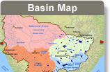
The map below shows the distribution of transboundary river basins in the Southern African Development Community (SADC) region.
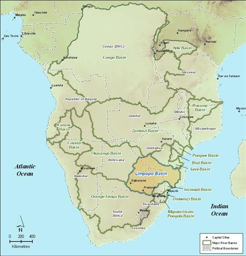
The International Basins of Southern Africa.
Source:Hatfield, 2010
( click to enlarge )