The Orange-Senqu basin stretches over four countries in Southern Africa: Lesotho, Botswana, Namibia and South Africa; with the river forming a part of the border between South Africa and Namibia.
The Orange-Senqu River is the largest and the longest river in South Africa. It rises in the eastern highlands of Lesotho, in the Maluti mountain range, where it is known as the Senqu River. The name changes to the Orange River at the border between Lesotho and South Africa, from which point the river flows across central and western South Africa to the Atlantic Ocean. The Vaal River, a major tributary of the Orange-Senqu River, originates from the Highveld escarpment in the north-east of South Africa. The confluence fo the Orange and Vaal Rivers is downstream of Douglas, to the west of Kimberley. The Vaal catchment forms one of the five major water management areas of the Orange River Basin.
The contributions to the overall flow of the Orange Senqu River are principally determined by rainfall. Estimates of mean annual rainfall per sub-basin are presented in the Climatic Patterns section of the Climate of the Orange Senqu River basin. About 60 % of the basin lies within South Africa, which contributes a significant amount of run-off to river system. Lesotho, with only 5 % of the total basin area, contributes over 40 % of the stream flow. Although a large portion of the basin lies within Namibia, it's runoff contribution less than 4 % (Earle et al, 2005).
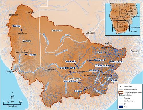
The major rivers and dams of the Orange-Senqu River basin.
Source:Hatfield 2009, after UNDP 2008
( click to enlarge )
Lakes
There are no naturally occurring lakes in the Orange-Senqu River basin, but there are a number of pans that form in localised depressions following heavy rainfall. A pan is a depression in which water collects when the soil layer is saturated, usually following heavy rainfall. Pans form where the water table is close to the surface, with water usually dissipating through evaporation, rather than outflow to a stream or river, but this is not excluded.
Dams
While there are no natural lakes, there are many man-made dams, storing large reservoirs of water for the purposes of irrigation; domestic and industrial water supply; flow control and hydroelectric power generation.
The major dams in the basin are:
-
Mohale and Katse dams in the Senqu sub-basin of Lesotho (portion of Upper Orange-Senqu basin in Lesotho)
-
Gariep and Vanderkloof dams in the Upper Orange sub-basin of South Africa (portion of Upper Orange-Senqu basin in South Africa)
-
Vaal and Bloemhof dams in the Vaal sub-basin of South Africa
-
Hardap and Naute Dams on the Fish River and the Otjivero Dam on the Nossob River in Namibia
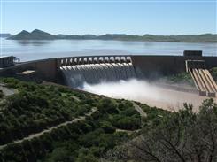 Gariep Dam, South Africa. Source:Pyke 2002 ( click to enlarge ) |
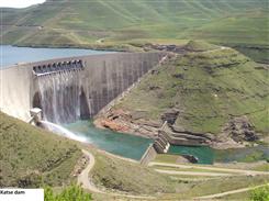 Katse Dam, Lesotho. Source:Lesotho Water Commission 2003 ( click to enlarge ) |
The numerous water abstractions and reservoirs in the Orange-Senqu River system have affected the annual availability of water for downstream users, and dampened the natural variability of runoff. The total annual flows have been reduced to a fraction of natural levels. In addition to reduced flows, these dams have also brought corresponding amplifications in inter-annual variability of flow. The seasonal variation in flow is now a fraction of what it used to be, with no discernible flood season having been seen in many years (ORASECOM 2007e).
Key statistics for the basin are provided in the table below.
Table: Basin indicators for the Orange-Senqu River basin.
|
Basin Area (km²):
|
941 351
|
|
Average Population Density (people per km²):
|
10
|
|
Number of Large Cities (>100 000 people):
|
4
|
|
Water Supply per Person (1995)(m³/year):
|
1 050
|
|
Degree of river fragmentation:
|
High
|
|
Number of Dams (>15m high) in Basin:
|
37
|
|
Number of Dams (>150m high) in Basin:
|
1
|
|
Number of Dams (>60m high) under Construction:
|
1
|
|
Number of Dams (>15m high) on Main Stem of River:
|
2
|
|
Number of Dams (>150m high) on Main Stem of River:
|
0
|
The long term environmental consequences of such changes are potentially very severe and could lead to the collapse of natural riverine ecosystems. Changes in flow are among the factors that have caused the ecological condition of the Orange River Mouth to deteriorate to the extent that its integrity as a functional protected Ramsar site is in jeopardy. The South African portion of the wetland has recently been placed on the Ramsar Montreux Record, denoting a need for urgent action (ORASECOM 2007e).
Surface Water Monitoring
Monitoring of surface water in the river basin is undertaken by the national departments of water in the four member states. In addition to the efforts of national authorities, a SADC-wide monitoring programme of automated flow-gauging stations, known as SADC HYCOS (Hydrological Cycle Observation System) has been put in place to facilitate regional hydrological information gathering and sharing. National surface water monitoring and SADC HYCOS are discussed in more detail in the Monitoring Flow section of the Hydrology of the Orange-Senqu River Basin chapter.
Further reading:
ORASECOM 2007b. Orange River Integrated Water Resources Management Plan - Review of Surface Hydrology in the Orange River Catchment.
ORASECOM 2007a. Orange River Integrated Water Resources Management Plan - Review of Existing Infrastructure in the Orange River Catchment.