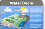
Surface water hydrology is the study of how water moves on the surface of the earth, and its distribution over space and time. Surface water is found in channels (streams and rivers), water bodies (lakes and reservoirs), and as runoff (water flowing on the surface outside defined channels, usually after a rainfall event). Streams originate from a source, such as a seep or a spring, flow downhill with gravity, and join other streams, eventually becoming a river.
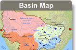
A drainage basin, also known as a catchment or watershed, includes all the land that drains into a river, from its source to its mouth (Dunne and Leopold 1978). The Orange-Senqu River drainage basin is defined as the land area drained by the Orange-Senqu River and all of its tributaries. A map showing the extent of the Orange-Senqu River basin is shown below, including the main surface water features.
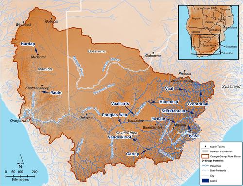
Surface Hydrology in the Orange-Senqu River basin.
Source:Hatfield 2009
( click to enlarge )
In arid and semi-arid regions, availability of water is greatly influenced by climate (precipitation and temperature), which determins the amount of water available and water flows within each year and between years. This hydrological variability caused by climate, together with topography, soils and land use, shapes the development and characteristics of surface water systems such as lakes and rivers.
Streamflow is the water flowing along a river channel. Discharge is the volume of water passing a certain point per unit time. Streamflow and discharge are usually measured by a hydrometric gauging station. Discharge can be calculated using the following equation:
Discharge (Q) = Channel Width (W) x Channel Depth (D) x Velocity of Water (V)
Discharge is dynamic, and changes over time. It depends on how much water is is available in a stream at a particular time. Discharge is visualized in a chart called a Hydrograph.
Pidwirny 2006.
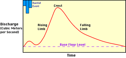
Demonstration hydrograph.
Source:Source: Pidwirny 2006
( click to enlarge )
A hydrograph shows:
-
The base flow level - the initial small rise in discharge (from normal flow conditions) when the water close to the river channel slightly increases the average flow;
-
The main discharge event - after a short lag, a steep increase in discharge, when the run-off from the closer parts of the basin enters the stream;
-
Falling discharge response - when water farther away in the basin enters the stream;
-
Return to normal flows.
The shape of a hydrograph is determined by:
-
Permanent factors – physical characteristics of the river basin, such as river channel morphology, slope, soils, vegetation cover
-
Transient factors – the variable elements of the rainfall event, such as the size, intensity and duration of the rainfall event