The Orange-Senqu is the third largest river basin in Southern Africa, extending into four riparian states: the Republic of Botswana, the Kingdom of Lesotho, the Republic of Namibia and the Republic of South Africa. It is considered an important natural ecological link between land and water resources in Southern Africa.
Basin Topography
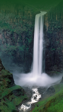
From its source in the Highlands of Lesotho, some 3 300m above mean sea level, to the border with South Africa, the topography of the Orange-Senqu River is steep. After reaching the border the landscape is more undulating.
In Botswana, where the river does not often actually flow regularly, the Molopo sub-basin is relatively flat, with very gentle relief throughout. Topographic lows are marked by broad, flat bottomed and dry valleys. In Namibia, the major tributary of the Orange-Senqu is the non-perennial Fish River, which when flowing, passes through deeply incised valleys before joining the main-stem Orange River close to the river mouth. Further upstream, are the Nossob and Auob Rivers that join close to the border with South Africa and Botswana, before they join the Molopo channel. Like the Molopo, these rivers flow very infrequently and surface water does not actually reach the main-stem river.
The downstream reaches of the river in South Africa, in the north western Karoo, Richtersveld and the area to the west of the Augrabies falls, often run through deeply incised valleys.
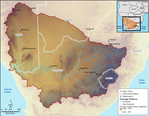
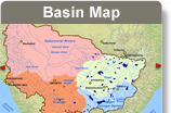
The landscape of the Orange-Senqu River basin.
Source:Hatfield 2011
( click to enlarge )
This map is supported below by a longditudinal profile of the main stem Orange-Senqu River, from its source in the Lesotho Highlands to the fiver mouth. Major dams and geographic features and towns are indicated along the route.
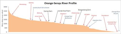
Longitudinal profile of the main-stem of the Orange-Senqu River.
Source:Hatfield 2009
( click to enlarge )
Landforms
The basin incorporates the central part of the RSA, which represents nearly half of the surface area of the RSA, the whole of Lesotho (where the main river is known as the Senqu), the southern portion of Botswana, and drains most of the southern half of Namibia.
From the landform map below, it can be seen that the land forms fall into three main categories:
-
Level land, dominating the majority of the central and western basin;
-
Sloping land, present in the Lesotho lowlands, Highveldt and Maluti-Drakensberg, as well as the southern portion of the basin (southern Karoo); and
-
Steep-land, present along the western boundary of the basin in the Southern Namib Desert and the Maluti-Drakensberg. Note: the map data presented below omits Lesotho, but from the relief map above, it can be seen that the steep-land category of landforms is also extensively present throughout much of Lesotho.
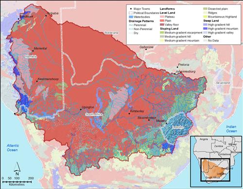
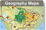
Dominant landforms of the Orange-Senqu River basin.
Source:FAO 2003
( click to enlarge )
There are six main geographical regions covered by the Orange-Senqu River basin, these are:
-
Great Escarpment Mountains
-
Highveld
-
Nama Karoo
-
Southern Kalahari
-
Namaqua Highlands
-
Southern Namib desert
The distribution of these geographic regions can be seen in the terrestrial ecoregions of the Orange-Senqu River basin, as seen in the map below.
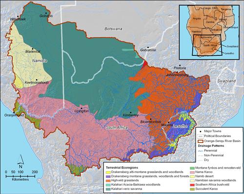
Terrestrial Ecoregions of the Orange-Senqu River basin.
Source:WWF 2004
( click to enlarge )