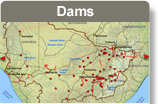
The expansion of commercial farms on the Namibian side of the river, opposite the Lower Orange WMA, is currently progressing at a rate that results in substantial seasonal increases in the areas under irrigation. While commercial farms, and in particular table grape vineyards, are expanding, the planting of cash crops has decreased. Along the border between Namibia and South Africa, irrigation is mainly for high value crops that require irrigation throughout the year. The area equipped for irrigation along the Orange River (this includes the Noordoewer Scheme and Aussenkehr Scheme) is about 2 000 ha.
There are currently 2 490 ha under irrigation in the two main irrigation projects in the Fish River Basin in Namibia – 2 260 ha at Hardap Dam (Aquastat Namibia 2009) and 290 ha at Naute Dam. There are also a number of riparian farmers along the river that are irrigating small areas of land. Since the river is not perennial, these farmers can only periodically abstract surface water.
High value crops, such as table grapes, require irrigation throughout the year.
Source:DRFN 2008
( click to enlarge )
The water that is used for irrigation at Hardap is measured and monthly consumption figures are available. The average annual consumption over a three-year period was 41,7 Mm³ with a minimum of 39,6 Mm³ and a maximum of 43,7 Mm³. The consumption at the Naute Project is estimated to be in the order of 4,6 Mm³ (Muir et al. 2004). The total abstraction from the Fish River at the two major developments amounts to approximately 46,3 Mm³/a. If the small scale abstraction of riparian farmers is added, it is unlikely that the total abstraction from the Fish River will exceed 48 Mm³/a.
This assumption does not consider the new Neckartal Dam, which will be located on the Fish River, 40 km west of Keetmanshoop. This dam with a catchment area of 45.365 km² will be Namibia’s biggest, about three times bigger than Hardap Dam. It is supposed to support 5 000 ha of irrigated agriculture. The tender for construction of the dam has been awarded to the the KL Construction company in July 2011.
Approximately 0,6 Mm3/a of the total agricultural demand in Namibia’s part of the basin is supplied from groundwater. Almost all-stock water is supplied from groundwater sources. This was estimated to be 4,5 Mm³/a (1999), and is expected to remain relatively constant or even decline slightly in the future.
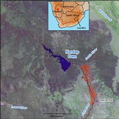 Irrigated areas downstream of Hardap Dam are indicated in red. Source:Hatfield 2009 ( click to enlarge ) |
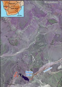 Irrigation close to the Naute Dam is indicated in red. Source:Hatfield 2009 ( click to enlarge ) |