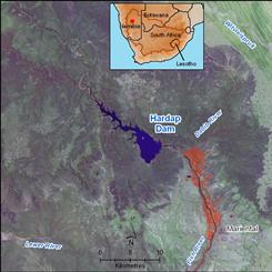
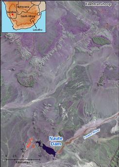
Hardap and Naute dams, two of the largest dams in Namibia, are located in the part of the Orange-Senqu River catchment which falls inside Namibia. These dams are used for urban and irrigation supply.
Naute Dam
Naute Dam located on a tributary of the Fish River, supplies water for urban consumption to Keetmanshoop. The dam has a full storage capacity of 84 Mm3. Raw water is treated at the dam in a purification plant with a capacity of 450 m3/h. The 44 km long purified-water pipeline from the dam to Keetmanshoop has a capacity of 56,5 l/s. Raw water is also supplied by gravity feed to a 270 ha irrigation scheme downstream of the dam.
Hardap Dam
Hardap Dam located on the Fish River supplies water for urban consumption to Mariental. The dam has a full storage capacity of 294 Mm3. Raw water is treated in a purification plant downstream of the dam, and gravity fed over a distance of about 20 km to Mariental.
The capacity and mean annual abstraction for the 6 major dams (which fall within the Orange-Senqu River basin) in Namibia is shown in Table 1.
Oanob Dam
The Oanob Dam is located 7 km to the west of the town of Rehoboth and its source is the Oanob River. The water from this dam is primarily used for irrigation and domestic supply to the town of Reheboth. The storage capacity of the dam is 34,505 Mm³ and the annual abstraction rate is 2,7 Mm³/a.
Otjivero Dam
The source of the Otjivero Dam is the White Nossob River and the main purpose of the dam is to provide water to Gobabis. The dam's storage capacity is 9,808 Mm³ and the annual abstraction rate is 0,6 Mm³/a.
Table : The capacity and mean annual abstraction for the 6 major dams in Namibia.
|
Dam Name
|
Capacity (Mm3)
|
Abstraction (Mm3/a)
|
|
Hardap
|
294,6
|
42,3
|
|
Naute
|
83,6
|
4,7
|
|
Oanob
|
34,5
|
2,7
|
|
Otjivero
|
9,8*
|
0,6
|
|
Tilda Viljoen
|
1,2
|
0,4
|
|
Dreihuk
|
15,5
|
01
|
* adjusted based on Namwater website information
 Hardap Dam, located on the Fish River, near Mariental, Namibia. Source:Hatfield 2009 ( click to enlarge ) |
 Naute Dam, located on the Lowen River, a tributary of the Fish River, provides water to the community of Keetmanshoop. Source:Hatfield 2009 ( click to enlarge ) |
Areas of irrigated agriculture are shown as being pink on the satellite images.
