Ecosystem Services in the Gariep River basin
The Southern African Millennium Ecosystem Assessment (SAfMA) included eight assessments, one of which that was an assessment of the Gariep River basin(this includes a large portion of the the Orange-Senqu River basin). The SAfMa defined the Gariep River basin as “the area of South Africa and Lesotho drained by the Senqu-Gariep-Vaal River system, as well as two primary catchments connected to this system by major water transfer schemes: the Tugela (or Thukela) in KwaZulu-Natal Province, and the Great Fish in the Eastern Cape Province” (SAfMA 2004). Therefore, it is important to note that Namibia and Botswana are not included in this assessment.
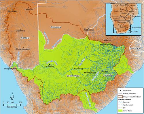
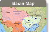
The Gariep Basin was the study area for the Southern African Millennium Ecosystem Assessment
Source:Hatfield 2009, after SAfMA 2004
( click to enlarge )
The table below illustrates the ability of ecosystems in the Gariep River basin study area to supply basic requirements for human well-being such as food, water, energy and minerals. This looks at whether there are adequate supplies and effective distribution, associated health impacts, and sustainability of provision.
Table: Ability of Ecosystems in the Gariep River basin to fulfill basic requirements for human well-being.
|
|
Food
|
Water
|
Energy Service
|
Mineral Service
|
|
Adequate supplies?
|
Basin can supply 50% more dietary energy and three times more dietary protein than needed.
|
Limits of current supply may be reached by 2025; climate change could exacerbate scarcity.
|
Fuel wood becoming increasingly scarce; coal supplies adequate for long-term (300 years). Investment in other energy sources and technologies remains limited.
|
Supplies abundant, but exploitation depends on economic viability.
|
|
Effective distribution?
|
Social inequality and disparity in income distribution make some sources of protein and energy unaffordable.
|
Free basic water to be granted to all but infrastructure is lacking. Some 5 million people still obtain water from rivers and springs and 16 million lack sanitation; others cannot afford to pay for additional water.
|
About 70% of South Africa electrified; 50% in rural areas; 3% of Lesotho. Connections remain unaffordable to many residents; environmental and social externalities not reflected in costs.
|
Largest benefits rarely accrue to those who bear the cost of mining’s externalities.
|
|
Implications for health?
|
Source of water and air pollution. Uses excessive amounts of water, causes land degradation. Fertilisers, pesticides, GMOs may have negative effects on health.
|
Pollutants in untreated water lead to potentially lethal water-borne diseases; infrastructure alters natural characteristics of water bodies and their regulating processes.
|
Coal-burning produces high carbon dioxide and sulphur dioxide emissions, affecting air quality, contributes to greenhouse gas emissions.
|
By-products of mining affect air and water quality; extraction creates excessive ecological disturbance, which interferes with ecosystem function and biodiversity.
|
|
Capacity of ecosystems to continue producing service?
|
Will require technological inputs to improve production; land degradation and climate change pose potential problems.
|
Will require implementation of resource protection measures and ecological reserve.
|
High capacity to produce coal and renewable sources; supply of fuel wood will depend on sustainable management.
|
High capacity for 30-year timeline.
|
Source: Bohenski et al. 2004
Hotspots are indicated by “irreplaceable areas for food production (able to supply caloric and protein requirements) and for biodiversity, areas in which water requirements are approaching available surface water supply, areas in which groundwater is high in salinity, municipalities in which one quarter of households or fewer have access to electricity from a local authority, municipalities with significant mining activity, and a synthesis map of several key services (Bohenski et al. 2004)”.
Regions in the basin that were identified as being critical for the provision of food or high levels of surface water runoff also coincided with the regions that had a high biodiversity value.
The high levels of agriculture and urbanisation are well-known concerns in the basin and have already affected its ecological integrity, with most of the indigenous grasslands under severe threat. The basin is a source of mineral wealth and contains several irreplaceable biodiversity sites, such as the Succulent Karoo (see the Box below) due to the concentration of many endemic species (Bohenski et al. 2004).
Box: Succulent Karoo
The Succulent Karoo’s botanical diversity is unparalleled by any other arid region on Earth. This eco-region is home to over 5 000 higher plant species, nearly 40% of which are endemic, and 18% of which are threatened. It has the richest succulent flora in the world, harboring about one-third of the world’s approximately 10 000 succulent species. Other unique features include the diversity of miniature succulents (435 spp.) and geophytes (630 spp.). The eco-region is also a center of diversity and endemism for reptiles and many invertebrate taxa, especially monkey beetles (Rutelinae: Hoplinii).
This eco-region extends down the western coast of Namibia from the town of Luderitz into South Africa, and then penetrating further inland. It comprises two major biogeographical domains, the Namaqualand-Namib Domain and the Southern Karoo Domain (Jürgens 1991). The Namaqualand-Namib Domain encompasses the fog-affected coastal plain and adjacent escarpment in the west. It is made up of several sub-regions: the Sperrgebiet of southern Namibia; the Richtersveld, which is a desert mountain region adjacent to the Orange River; the Sandveld, or sandy coastal plain, south of the Orange River; the Hardveld, or granitic uplands, of the Great Escarpment; the Kamiesberg, a granite massif of 1 800 m along the escarpment; and the quartz-strewn plains of the Knersvlakte in the extreme south. This domain receives most of its rain in winter.
Source: World Wildlife Fund 2001
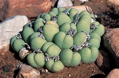 Crassula congesta, an example of the unique vegetation found in the Succulent Karoo. Source:Karoo. Source:© Olivier Langrand/ Conservation International ( click to enlarge ) |
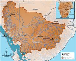 Distribution of the Succulent Karoo terrestrial ecoregion. Source:after WWF 2003 ( click to enlarge ) |