Welcome to the first surface water quantity report of the Orange-Senqu River Commission (ORASECOM), for the hydrological year 2020-2021. For Read more
Categories
Latest Submission
2020-2021 Orange-Senqu Surface Water Quantity Synoptic Analysis
Khakea-Bray Transboundary Dolomite Aquifer Recharge Assessment
Documentation and Data: A read-only folder structure of all reports, data, and models related to the STAS can be accessed Read more
Improving Groundwater Knowledge in Selected Transboundary Aquifers
Documentation and Data: A read-only folder structure of all reports, data, and models related to this study can be accessed Read more
Stampriet Transboundary Aquifer System (STAS) – Governance of Groundwater Resources in Transboundary Aquifers (GGRETA) Project
Documentation: A read-only folder structure of all reports, data, and models related to the STAS can be accessed from here: Read more

- WIS > Infrastructure > Orange-Senqu Infrastructure Catalogue: Flow Gauges
Orange-Senqu Infrastructure Catalogue: Flow Gauges
- Author:Bennie Haasbroek
- Post date:23 October, 2013
- Categories:Infrastructure
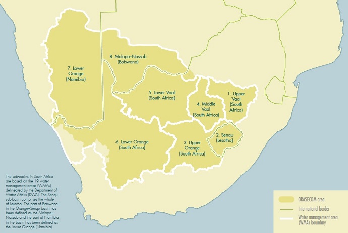
The Orange-Senqu Infrastructure Catalogue groups Flow Gauging Stations in the Orange-Senqu River according to the sub-areas in the map below.
For more detail on the Flow Gauging Stations please select the appropriate area below:
- Lower Orange (Namibia) Schematic
- Lower Orange (South Africa) Schematic
- Lower Vaal Schematic
- Middle Vaal Schematic
- Molopo-Nossob Schematic
- Senqu Schematic
- Upper Orange Schematic
- Upper Vaal Schematic
The entire Infrastructure catalogue can be downloaded here (20MB)
Source:
The Orange–Senqu River Basin Infrastructure Catalogue, ORASECOM Report 001/2013
Compiler:
Allan Bailey of Royal Haskoning DHV (allan.bailey@rhdhv.com)
Funding Agency:
Global Environment Facility (GEF) through United Nations Development Programme (UNDP)


Comments
You must be logged in to post a comment.