Welcome to the first surface water quantity report of the Orange-Senqu River Commission (ORASECOM), for the hydrological year 2020-2021. For Read more
Categories
Latest Submission
2020-2021 Orange-Senqu Surface Water Quantity Synoptic Analysis
Khakea-Bray Transboundary Dolomite Aquifer Recharge Assessment
Documentation and Data: A read-only folder structure of all reports, data, and models related to the STAS can be accessed Read more
Improving Groundwater Knowledge in Selected Transboundary Aquifers
Documentation and Data: A read-only folder structure of all reports, data, and models related to this study can be accessed Read more
Stampriet Transboundary Aquifer System (STAS) – Governance of Groundwater Resources in Transboundary Aquifers (GGRETA) Project
Documentation: A read-only folder structure of all reports, data, and models related to the STAS can be accessed from here: Read more
- WIS > Biota and Ecosystems > Baseline monitoring of aquatic ecosystem health in the Orange-Senqu River Basin
Baseline monitoring of aquatic ecosystem health in the Orange-Senqu River Basin
- Author:Bennie Haasbroek
- Post date:14 November, 2013
- Categories:Biota and Ecosystems,Surface Water Resources
Purpose
The specific purpose of this assignment was to undertake the first baseline monitoring of aquatic ecosystem health in the Orange-Senqu River System and to support the broader joint baseline survey. The focus of this specific assignment was to investigate the Aquatic Ecosystem Health of the Orange-Senqu River System and includes a detailed assessment of aquatic ecosystem health indicators, including the impacts affecting these systems.
Funding Organisation(s):
Reports:
- Dickens, C. 2009. The OSAEH Programme – Orange-Senqu Aquatic Ecosystem Health Monitoring Programme. ORASECOM Report Number 009/2009.
- Todd, C & Koekemoer, S. 2011. Baseline Monitoring of Aquatic Ecosystem Health in the Orange-Senqu River Basin: Part 1: Summary Report
- Todd, C & Koekemoer, S. 2011. Baseline Monitoring of Aquatic Ecosystem Health in the Orange-Senqu River Basin: Part 2: Main Report
Maps:
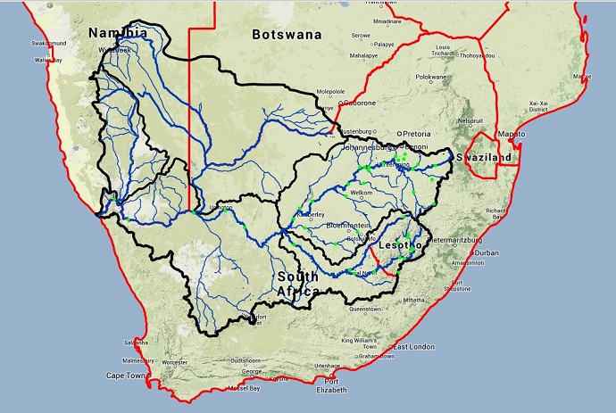
To browse the map and the sites go to the WIS Map and select the layer “Ecological Sites”. Clicking on the sites will reveal the number of the site. The GIS shapefiles for the sites can be downloaded here.
Data:
Comments
You must be logged in to post a comment.