|
Hydrology: Hydrology of the Orange-Senqu River Basin:
Groundwater |
Groundwater in SADC
Groundwater is a critical source of water for people living in the SADC region, with approximately 37 % of the population of the region relying on formal or improved groundwater sources, 23 % from formal surface water supplies, and 40 % relying on unimproved groundwater and surface water sources (SADC 2011). This level of dependence is combined with the fact that approximately one third of the population of the region live in drought-prone conditions, making groundwater an even more precious resource (SADC 2011).
As part of the Regional Strategic Action Plan, SADC is leading a Groundwater and Drought Management Project. One of the primary outputs of this project will be the creation of a Regional Groundwater Management Institute of Southern Africa, to be located at the University of Bloemfontein, in South Africa.
In addition to the materials provided below, the Document library provides access to a series of Groundwater Briefing Notes created by the World Bank GWMate team.
Groundwater Resources in the Orange Senqu River Basin
Groundwater is used extensively throughout the southern African region, including the Orange-Senqu River basin, supplying a large percentage of water for irrigation and rural water supply schemes (FAO 2004). This is especially true in rural areas of the Lower Orange River basin, located away from surface water resources. It is estimated that groundwater is the largest source for drinking and livestock water supply, with approximately 37% of the population of the SADC existing solely on groundwater resources (SADC 2001).
Also available in the Document Library are the Cap-Net Groundwater Management in IWRM Training Manual and the UNESCO publication 'Transboundary Aquifers: Managing a Vital Resource'
Recent estimates put groundwater abstraction in South Africa between 1 771 Mm³/a and 1 900 Mm³/a (Baron & Seward 2001; DWAF 2004c; Hughes 2005). However, the actual usage of groundwater is largely unknown; there is currently no formal data collection on groundwater usage in South Africa (CSIR 2004), or any of the other countries in the basin. In Namibia, groundwater extraction from the Orange-Senqu River basin was estimated at 13,81 Mm³/a and in Botswana 1,12 Mm³/a (Lange et al.). There are no data available for groundwater abstraction in Lesotho.
Groundwater is used extensively throughout the southern African region, including the Orange-Senqu River basin, supplying a significant percentage of water for irrigation, industrial, mining, domestic and rural water supply schemes. This is especially true in rural areas, located away from surface water resources.
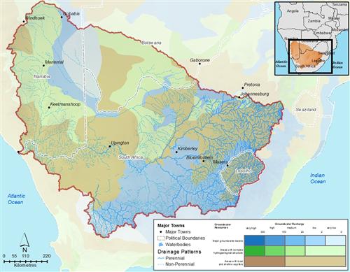
The map below, generated by the WHYMAP initiative illustrates the distribution of groundwater resource types and recharge potential across the basin.
Aquifers
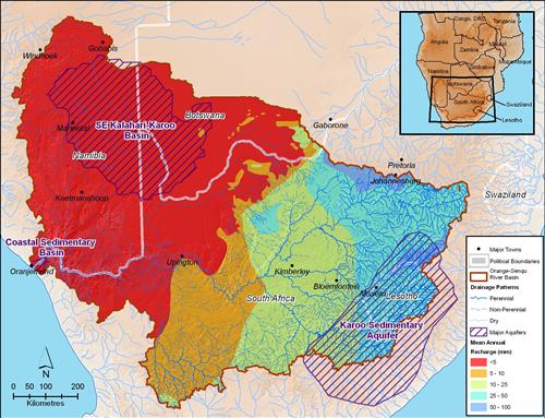
There are two main types of aquifers governing the occurrence and distribution of groundwater in the Orange-Senqu River basin: shallow alluvial primary aquifers along the river, and a variety of deeper hard rock secondary aquifers. Alluvial aquifers are generally only recharged by surface water, and are usually considered part of that resource. The secondary aquifers in the basin mainly used to supply water to smaller rural towns for rural domestic needs and stock-watering, with no major production well-fields serving large concentrated demands.
The sandstones aquifers of the Beaufort Group (the third main sub-division of the Karoo Super group) are considered to be weak primary aquifers. The secondary aquifers in the basin are formed in the fractures or faults of weathered rock, such as in the Karoo Super group. A map of the major trans-boundary aquifers in the Orange-Senqu River basin is provided in the map above.
The primary and secondary aquifers that occur in the basin are described below:
Box : Primary and Secondary Aquifers Found in the Orange - Senqu Basin
Dolerite Intrusions: Numerous dolerite dykes and sills have intruded the sediments of the Karoo Super group throughout the basin. The dolerite themselves, or the baked contact zones between the dolerite and the surrounding country rock are fractured and thus act as secondary aquifers. Dolerite intrusions in competent host rocks such as the thick sandstones have generally higher groundwater potential than intrusions in less competent rocks such as shale. The highest groundwater yields would occur where a fractured dolerite/contact zone is overlain by saturated alluvium or crossed by a perennial watercourse as this would facilitate and promote aquifer recharge.
Fractured Sedimentary Rocks: Tectonic stress, for example, and the resultant folding and faulting have caused the fracturing of sedimentary rocks and these fractures result in the formation of secondary aquifers. The fracturing is most pronounced in competent (hard) sandstone units such as those found in the Beaufort Group.
Weathered Zone: Weathered zones in which secondary porosity is created may also act as aquifers. Shales and mudstones are more easily eroded than sandstone and this form of aquifer is therefore often developed within the shales of the Ecca Group.
Alluvial Deposits: These have primary porosity and are developed to a limited extent along certain sections of the river.
Karstic Fractured Aquifers: These are represented by the Transvaal dolomite units, which are relatively smaller in areal extent found mainly in ephemeral rivers sub-basin area.
Source: Orasecom 2007d
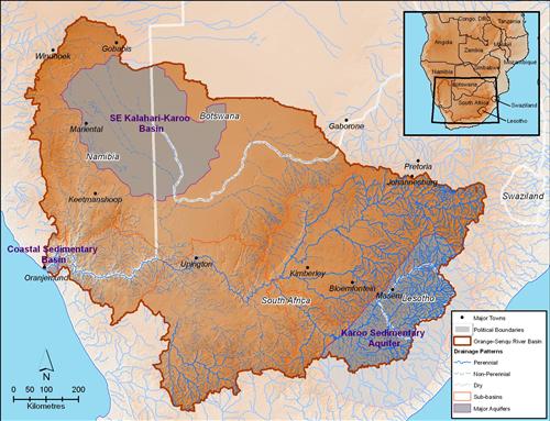
Trans-boundary Aquifers
In addition to the local aquifer systems, the Orange-Senqu River basin includes a series of trans-boundary aquifers. These aquifers are particularly important as they are shared by two or more countries, requiring cooperative management of water use/abstraction and sources of pollution that may affect them. The map below is a regional overview of these trans-boundary aquifers, broken down into four key categories:
- Pre-Cambrian 'Basement' aquifers
- Volcanic Rocks
- Consolidated sedimentary rocks (Cambrian and younger)
- Unconsolidated sediments (mainly Quaternary).
As can be seen from this map, the five trans-boundary aquifers in the Orange-Senqu River basin are as follows:
- Karoo Sedimentary Aquifer;
- Ramotswa Dolomite Basin;
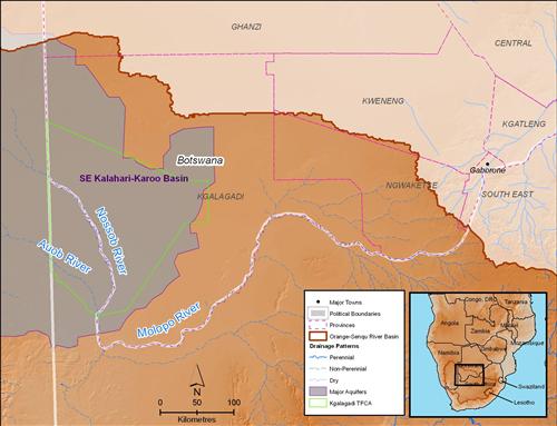
- South East Kalahari/Karoo Basin;
- Northern Kalahari/Karoo Basin; and,
- Coastal Sedimentary Basin
Exploitation of Groundwater
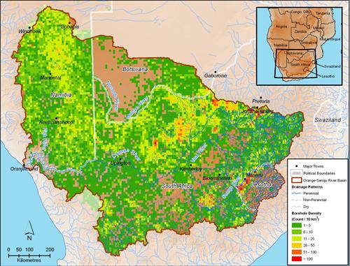
Groundwater is primarily abstracted through boreholes (groundwater wells), drilled from the surface by a drilling rig. Boreholes are the most common form for abstracting groundwater in southern Africa. The map below shows the density of boreholes across the Orange-Senqu River basin (number of boreholes per 10 km². It can clearly be seen that the density is highest in and around urban areas and throughout agricultural areas of the basin.
While there are no major well-fields operating in the Orange-Senqu River basin, dependence on groundwater is very high, particularly in the Lower Orange River region, the ephemeral rivers region and at the Orange River Mouth. Groundwater in the Molopi/Nossob drainage system is exploited via the Tsabong Groundwater Resources project (see map below for location). While official reports suggest that the environmental impact of this project is minor, concern has been expressed about the impact lowered groundwater levels may have on trees in the area (ORASECOM 2007d).
Furthermore, there is regional interest in developing and managing the wider use of groundwater to meet water demands in rural settlements in the entire basin. A case in point is the SADC-wide groundwater project (SADC 2009). To learn more about the role groundwater plays in water supply in the Orange-Senqu River basin, please refer to the Groundwater in the Basin section of the Resource Management Chapter.
Groundwater Information
The majority of groundwater information available in the region is at a country-level, with very little information aggregated at a basin or regional scale. SADC, supported by international financial and technical agencies, is currently leading an initiative to develop regional groundwater information resources to support transboundary water resources management and cooperation.
Further reading:
![]()