|
Geography: Geomorphology:
Geology |
The Influence of Geology on the Landscape
There is a close relationship between soils and the geology of the rocks that lie beneath them. Most soils are weathered and modified sediments from underlying bedrock, or have been transported to their present location by some form of mass transit.
Another relationship that it is important to recognise is the close link between geology and geohydrology/groundwater. The lithology and geological structure of a region has a direct result on the storage, quality, availability and recharge potential of groundwater resources.
The geology of the Orange-Senqu basin naturally affects the distribution, availability, quantity and quality of groundwater in the basin. Most of the aquifers of the Orange-Senqu River basin are situated in hard rock, characterised by dual porosity, or secondary aquifers associated with fracturing of the rock matrix and weathering (UNEP 2009 and Cobbing et al. 2008).
Groundwater is a critical component of the water resources of the basin and is discussed in more detail in the groundwater section of the Hydrology chapter.
The map below illustrates the simplified surface lithology of the Orange-Senqu River basin. This map was generated as part of the SADC Hydrogeological Mapping Project.
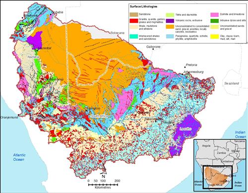
Geology of the Orange Senqu River Basin
The present landscape of the Orange-Senqu River basin was formed by geological events that occurred over millions of years. They have been described below, by sub-basin.
The Vaal Sub-basin
The Vaal sub-basin extends above 2000m at the eastern periphery, descending to lower elevations westwards towards the Orange River. The dominant rock formations are sedimentary with patches of igneous and metamorphic formations occurring around the northern and north-western edge of the sub-basin, all associated with the Karoo complex.
Upper Orange–Senqu Sub-Basin
To the east, the Upper Orange-Senqu sub-basin is dominated by mountains exceeding 3 000 amsl (above mean sea level), making this area the highest elevation in the entire Orange-Senqu River basin.).The dominant rock formation is igneous with patches of sedimentary rocks occurring towards the southern parts of the sub-basin, associated with the Karoo complex.
Lower Orange-Senqu Sub-Basin
The Lower Orange-Senqu sub-basin is bordered by the Upper Orange-Senqu and the Vaal sub-basins and extends from an area reaching above 1 500m amsl in the eastern peripheries, descending to lower elevations north-westerly towards the Orange River. The dominant rock formation is sedimentary (mudstone and sandstone), with patches of igneous rocks occurring in several places in the sub-basin, all is associated with the Karoo complex.
Northern Ephemeral Rivers
In the northern most part of the basin, Damara schists and Nosib quartzites tend to dominate the geology. The Stampriet Artesian basin lies in the central-eastern section of the area, stretching from Namibia into Botswana. Here artesian Nossob and Auob sandstones are separated and overlain by shale horizons under the sediments of the Kalahari Sequence. In the Fish River catchment to the west, the area mainly consists of Nama-aged sandstone, shales and limestone. Karoo and Nama lithologies as well as Dolerite intrusions can be found in the southern section and Kalahari sediments occasionally overlie these lithologies (ORASECOM 2008a,b).
In the Botswana portion of the Molopo sub-basin system, outcrops of bedrock are restricted to the river valley and the Mosi Ridge. The area is characterised by sands, loamy sands and occasional clays. The vegetation is fairly open grassland savannah with some patches of savannah woodlands and dense stands of trees and shrouds close to the Molopo River valley. The area between Mabule and Werda is generally flat with a slight increase in elevation to the east.
In the North West Province of South Africa, dunes associated with the arid environment of the Kalahari occur in the extreme western region. The area also has an interesting and ancient geological heritage, including rich mineral depositsand paleontological artefacts. Igneous rock formations dominated the north-eastern and north-central regions of the province as a result of the intrusion of the Bushveld Complex. Ancient igneous volcanic rocks dating back to the Ventersdorp age (more than 2 000 million years) appear to be the dominant formations in weastern and southern regions of the province
Orange River Mouth
The estuary is located on hard rock formations, made up of greywacke, quartzite and lava deposits (ORASECOM 2006). The corresponding geology is a complex of unconsolidated superficial deposits, conglomerate, limestone, sandstone, marl and high-level gravel. Phyllite, lava, quartzite, schist, tillite and hornfels can also be found in many places (ORMTFCA 2000).
Detailed historical evidence of the human occupation and activities in the estuary, from pre-history until present, are provided in ORMTFCA
One of the most impressive geological formations in the area is found around the Richtersveld, a mountainous region between the Orange River Mouth and the town of Vioolsdrift. This area has stunning mountain scenery, which is cleaved by the passage of the Orange River and is generally regarded as one of the most impressive mountain deserts in the world. Gneisses and pegmatite’s and various other meta-sediments and meta-volcanics make up the geology of the area. The rocks are between 600 million and 1 500 million years old and are particularly impressive because there is no vegetation to hide the results of the metamorphic processes that have occurred. Huge folds and faults are clearly observable throughout the whole area as are the pegmatite’s, which are often exposed as white outcrops in an otherwise brown landscape (DWAF 2008).
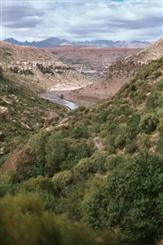 Makhaleng River Gorges in the Highlands of Lesotho. Source:Pecher 2003 ( click to enlarge ) |
Lithostratigraphic units found in Orange-Senqu River Basin
A lithostratigraphic unit is a geological rock recognised by observable physical features and not by its inferred age, the time span it represents, inferred geologic history, or manner of formation.
The main lithostratigraphic units of the Orange-Senqu River basin are as follows:
- The Namaqualand-Natal Basement Complex
- Ventersdorp Supergroup
- Griqualand West Sequence
- Abbabis and Kheis Groups
- Damara Sequence
- Karoo Senquence/Complex
- Kalahari Red Sand
![]()