
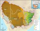
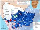
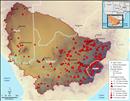
 Relative Drought Hazard Index for the Orange-Senqu River basin. Source:Leira et al. 2002 ( click to enlarge ) |
 Predicted medium term temperature change (present until 2046-2065) Source:Hatfield 2009, after NeWater 2009 ( click to enlarge ) |
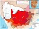 Predicted long term temperature change (present until 2081-2100) Source:Hatfield 2009, after NeWater 2009 ( click to enlarge ) |
 Predicted medium term change in streamflow (present until 2046-2065) Source:Hatfield 2009, after NeWater 2009 ( click to enlarge ) |
 Predicted long term change in streamflow (present until 2081-2100) Source:Hatfield 2009, after NeWater 2009 ( click to enlarge ) |
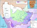
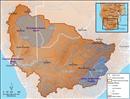
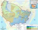
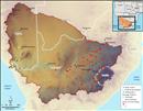
 Surface Hydrology in the Orange-Senqu River basin. Source:Hatfield 2009 ( click to enlarge ) |
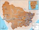
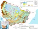
 Stream Order of the Orange-Senqu River System. Source:Hatfield 2009, after DWAF 2004 ( click to enlarge ) |
 Major groundwater aquifers relative to the surface basin. Source:Hatfield 2009, after UNDP 2008 ( click to enlarge ) |
 Groundwater Resources of the Orange-Senqu River basin. Source:WHYMap 2009 ( click to enlarge ) |
Transboundary aquifers in the SADC region Source:IGRAC 2005 ( click to enlarge ) |
 Tsabong Groundwater Resource Project location. Source:Hatfield 2009, adapted from UNDP 2008 ( click to enlarge ) |
 SADC Hydrogeological Map for the Orange-Senqu River basin. Source:SADC 2010 ( click to enlarge ) |
 Approximate water balance for natural runoff in the Orange-Senqu River basin. Source:Hatfield 2009, after ORASECOM 2007f ( click to enlarge ) |
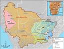
 A map of the major water uses in the basin. Source:Hatfield 2009 ( click to enlarge ) |
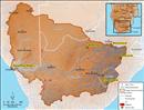
 Gauging stations in the Orange-Senqu River Basin Source:ORASECOM 2011 ( click to enlarge ) |
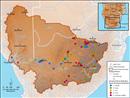
 SADC HYCOS Stations in the Orange-Senqu River Basin. Source:ORASECOM 2011 ( click to enlarge ) |
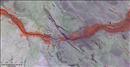 Extent of irrigation along the Orange-Senqu River, near the towns of Keimoes, Karkamas and Augrabies, South Africa. Source:Hatfield 2009 ( click to enlarge ) |
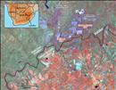 Gold mines along the Vaal River near Klerksdorp in the North West Province of South Africa. Source:Hatfield 2009 ( click to enlarge ) |
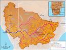
 Wetlands of the Orange-Senqu River basin (limited data available for Lesotho). Source:Hatfield 2009, after Ramsar 2009 ( click to enlarge ) |
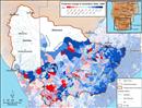
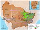
 Draft Aquatic Ecosystem Health Map (2003-2008) for the Orange-Senqu River basin. Source:Hatfield 2009, after ORASECOM 2009 ( click to enlarge ) |