|
Resource Monitoring:
Monitoring Systems in the Basin Countries |
To develop and manage water resources sustainably across a large river basin such as that of the Orange-Senqu River, decision makers need sufficient and reliable hydrological and geohydrological data. Hence one of the greatest challenges of transboundary water management lies in the sharing of data between different actors, and the integration of monitoring programmes across boundaries. For information about how to access monitoring data for each country see the Information Systems section.
Current monitoring activities in each basin state are summarised below.
Botswana
In the Orange-Senqu River basin in Botswana, there is no perennial surface water to monitor; however, there are 500 groundwater wells (boreholes). Current monitoring programmes cover abstraction in 27 field wells, water quality testing in production boreholes, groundwater levels in observation boreholes, chloride concentrations in rainfall, and soil moisture content. The responsible authorities are the Department of Water Affairs (DWA), Department of Geological Survey, Debswana, District Councils and others (SADC 2009). The non-centralised organisation of monitoring in Botswana hinders effective water management.
The monitoring section of DWA carries out monitoring of groundwater levels and abstraction quantities. Counting boreholes monitored by the DGS, a total of approximately 800 boreholes are monitored. Water levels in these boreholes are generally measured manually, with only 57 boreholes equipped with continuous recorders. The recorders (when functioning properly) provide a continuous measurement of water level fluctuations. The recorders are maintained by DGS, and to a lesser degree by DWA, who in theory visit them on a monthly basis. DWA also receives data from non-governmental organisations that operate well-fields.
Lesotho
The Groundwater and Water Pollution Control Divisions of DWA are responsible for groundwater exploration, management and resource assessment at national and district level. This includes the monitoring of groundwater abstraction and water quality.
In Lesotho, the monthly discharge and chemical properties of 84 wells have been monitored since 1994. Water level is monitored in 42 observation wells (as of 1992) and all new wells require chemical analyses. The hydrogeology section in the DWA monitors most wells; discharge rates in wells are monitored by WASA (SADC 2009).
Biophysical monitoring of the Lesotho Highlands Water Project area (which includes surface water monitoring) is being conducted by the Environment and Social Services Group of the Lesotho Highlands Development Authority over the lifetime of the project. Hydrology, habitat, water quality, riparian vegetation, macro-invertebrates and fish are being measured in seven potentially impacted sites and compared with two reference sites (LHWP 2009).
Namibia
Borehole loggers and recorders operate at selected groundwater-dependant towns and villages, and water levels are monitored in the Stampriet Artesian Basin (south of Gobabis and east of Mariental). During a recent Japanese-funded development project, ten additional observation boreholes were drilled to monitor the hydraulic characteristics of the Kalahari, Auob and Nossob aquifers.
Rainfall stations are operated and maintained by the meteorological services of DWA and NamWater. In the Namibian sub-catchments of the Orange-Senqu River basin there are a total of 284 rainfall stations in operation, and 25 streamflow gauging stations, three maintained by NamWater and the remainder by DWA.
In Namibia there are 912 groundwater wells, of which 112 are monitored using autographic recorders and 800 measured by hand under the National Groundwater Monitoring Programme. There is little or no groundwater quality monitoring. The Department of Water Affairs in the Ministry of Agriculture, Water and Rural Development and NamWater are responsible for monitoring (SADC 2009).
South Africa
Surface Water
The Department of Water Affairs (DWA) continuously monitors streamflow on all major rivers in South Africa, including those within the Orange-Senqu River basin. This is carried out with conventional streamflow logging equipment. Monitoring tracks both accumulation of water at certain points and abstraction by water users. Water samples are periodically collected and analysed, to indicate the health of the water resource and its suitability for use (DWAF 2009b).
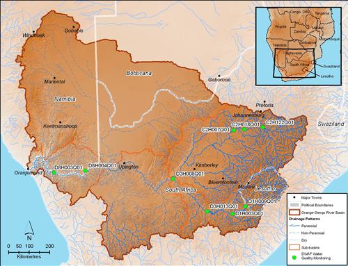
The map below shows the monitoring stations that are most comprehensive in terms of long-term monitoring of numerous analytes throughout the basin. See Water Quality for a detailed discussion about water quality results at these stations over time.
Groundwater
There are 369 groundwater monitoring points in South Africa, sampled twice a year in October and April by Department of Water Affairs (DWA). A comprehensive geospatial dataset for 2002 groundwater quality can be retrieved from the second national Groundwater Resource Assessment (GRA II) (DWAF 2009b).
Groundwater levels and quality are currently recorded on a continuous basis at several sites. DWEA is currently refining and developing the present system to create an integrated monitoring network at three levels:
- National monitoring by the Department in relatively un-impacted areas to provide background and baseline information on water levels and water quality.
- Monitoring of major aquifers by Catchment Management Agencies (CMAs) to determine trends in water levels and quality resulting from human activity. These will initially cover only physical and chemical monitoring (no biological). DWEA will continue with this monitoring until the CMAs can take over the responsibility.
- Local impact monitoring. Information provided by users during licence applications or water use authorisations will be an important source of information on groundwater use. Additional information will be derived from reports on conditions encountered during borehole drilling.
At a national scale, DWEA implements the National Monitoring Programme (NMP). The NMP may be divided into:
National Chemical Monitoring Programme (NCMP)
The NCMP is designed to report on the chemical quality of South Africa's surface waters. Information about major inorganic chemical water quality constituents of surface waters across South Africa allows water resource managers, scientists, decision-makers, and the public to make informed decisions. All parameters are measured against the national water quality requirements of the two dominant user groups: domestic and agricultural.
National Eutrophication Monitoring Programme (NEMP)
Eutrophication can harm an ecosystem (via deterioration of water quality and loss of biodiversity), and degrade aesthetic value and recreational and human health values. These in turn have negative economic impacts. Many South African impoundments exhibit high nutrient enrichment and eutrophication related problems, due mainly to agricultural run-off and effluent. The NEAP includes 80 impoundments monitored annually in South Africa; many more require regular monitoring.
National Microbiological Monitoring Programme (NMMP)
The NMMP aims to directly monitor faecal pollution, in terms of the microbial quality of surface water resources in priority areas. The results allow assessment of health impacts related to faecally polluted waters.
National Aquatic Ecosystems Health Monitoring Programme (NAEHMP)
The most widely known component of the NAEHMP is the River Health Programme (RHP). The RHP monitors the overall ecological status of riverine ecosystems in South Africa. The RHP primarily uses in-stream and riparian biological communities (e.g. fish, invertebrates, vegetation) as indicators of in-stream and riparian disturbance. To learn how the integrity or health of the biota inhabiting a river ecosystem provides a direct and integrated measure of the health of a river as a whole, see Life in Aquatic Ecosystems.
Atmospheric Monitoring
The Regional Remote Sensing Unit (RRSU) monitors agro-meteorological data, including rainfall in SADC countries, as a way to prepare farmers for climatic conditions during the growing season. The RRSU is part of the Food, Agriculture and Natural Resources Directorate of SADC (one of the four directorates), as is the Drought Monitoring Centre, which monitors meteorological, environmental and hydrological-meteorological information in the region (FANR 2009).
![]()