|
Hydrology: Hydrology of the Orange-Senqu River Basin:
An Overview of Water Use and the Water Balance in the Orange-Senqu River Basin |
The Orange-Senqu River system provides the single largest water resource south of the Zambezi. The region is classified as semi-arid and is subject to increasing water stress. Only in temperate Lesotho highlands do annual rainfall exceed evaporation. In the Lower Orange, water resources are severely limited, with annual evaporative losses far exceeding annual rainfall. This creates problems in densely populated areas with high expectations for the supply of water to support economic development.
As stated in the Principles of Hydrology section, Water balance is the concept used to understand the availability and the overall 'state' of water resources in a hydrological system, considering all of the inflows and outflows into and from the basin.
The information below presents an initial water balance budget. However, a more complete and holistic water balance estimate is required if the objectives of integrated water resources management are to be met in the Orange-Senqu River basin.
The map below shows the estimated general water balances for the Orange-Senqu River basin, calculated as a ratio of run-off against water use per sub-basin.
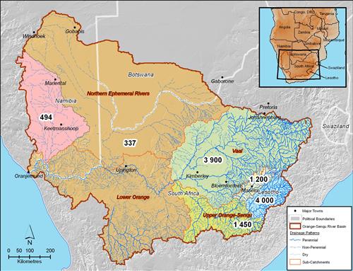
To compute the water balance of the basin, ORASECOM has completed studies on water balance of the basin (ORASECOM 2007b). According to study reports by DWAF (2008) and ORASECOM (2007a,b), the actual runoff reaching the river mouth (approximately 5 500 Mm³/annum) is considerably less than the natural value (over 10 900 Mm³/annum). The difference is mainly down to extensive water utilisation in the Vaal River basin, mostly for domestic and industrial purposes. Large volumes of water are also used to support extensive irrigation (approximately 1 800 Mm³ annum) and mining operations (approximately 40 Mm³/annum).
In addition to the water demands mentioned above, evaporation losses from the Orange River and the associated riparian vegetation account for between 500 Mm³/annum and 1 000 Mm³/annum depending upon the flow of water in the river and its surface area.
An approximate water balance for the Orange River is given in the table below, providing an overview of the various demands on water, and transfers, in the Orange-Senqu River basin.
Table: Water balance in the Orange-Senqu River basin.
|
Water Balance Component |
Volume (Mm³/a) |
|
Environmental Requirement |
9001 |
|
Namibia |
1202 |
|
Lesotho & Transfers to South Africa |
8203 |
|
South Africa Orange River Demand |
2 5604 |
|
South Africa Vaal River Demand |
1 5605 |
|
Evaporation & losses |
1 7506 |
|
Spillage |
3 7807 |
|
Total |
11 490 |
|
Spillage under natural conditions |
10 900 |
|
Notes |
|
The Lower Orange (Fish River excluded) sub-catchment area represents approximately 35 % of the total Orange River catchment area; however, only 3 % of the runoff reaching the Orange River is generated there. Conversely, 35 % of the runoff is generated in the Senqu catchment, which represents less than 3 % of the total Orange River catchment area (ORASECOM 2007a).
Water Demand
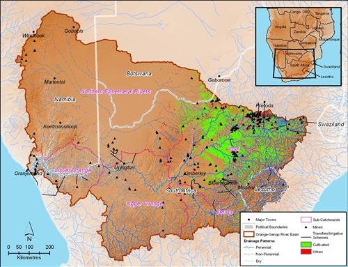
Demand for water to support agriculture and industry has driven the large water transfer schemes implemented across the upper catchment area. Higher than average rainfall in this area allows excess water to be redistributed, through water transfer infrastructure, to meet the water demands of the metropolitan areas of Johannesburg and Pretoria.
Other water transfers and irrigation schemes implemented in the Orange-Senqu River basin support agricultural production in areas that are either too dry or subject to excessive variability in rainfall.
The Botswana side of the basin is very flat and arid, and has not contributed water to the main stream in recent history. Thus, the Orange is also not a very practical resource for south-eastern Botswana, as existing demand centers are far from the river.
In the case of Lesotho, national water demands are relatively small; abstractions create relatively minor impacts downstream and do not present a significant conflict risk. However, the Lesotho Highlands Water Project (LHWP) development, which transfers water from the Senqu River to the Vaal System, has a significant impact on the flows from the Senqu River in Lesotho to the Upper Orange River in South Africa.
The Orange-Senqu River comprises three main surface water resource components which are essentially operated as separate systems (DWAF 2008). These three independently operated water management systems provide water to the populations of the Orange-Senqu River basin for domestic, agricultural and industrial use.
Box: Main
The Lesotho Highlands Water Project (LHWP) – The project includes two major dams, Katse Dam (on the Malibamutso River and Mohale Dam (on Senqunyane River, and Matsoku Weir (on the Matsoku River, to provide water to the Upper Vaal River through a system of interlinking tunnels.
The Vaal River System – This system, imports from other basins, and operates separately to meet demand in the Vaal Catchment>. The Vaal River system is kept a closed system to minimise the impact of poor quality Vaal water on the cleaner Orange River.
The Orange-Senqu River System, excluding the Vaal River System – The operation of Vanderkloof and Gariep dams does not make any allowances for possible inflows from the Vaal system.
Source: DWAF (2008)
The Lesotho Highlands Water Project (LHWP) – The project includes two major dams, Katse Dam (on the Malibamutso River and Mohale Dam (on Senqunyane River, and Matsoku Weir (on the Matsoku River, to provide water to the Upper Vaal River through a system of interlinking tunnels.
The Vaal River System – This system, imports from other basins, and operates separately to meet demand in the Vaal Catchment>. The Vaal River system is kept a closed system to minimise the impact of poor quality Vaal water on the cleaner Orange River.
The Orange-Senqu River System, excluding the Vaal River System – The operation of Vanderkloof and Gariep dams does not make any allowances for possible inflows from the Vaal system.
Further reading:
![]()