|
Geography:
Vegetation/Landcover |
Vegetation
Currently there is no consistent map of vegetation for the entire Orange-Senqu River Basin. Each country has a national vegetation map available in one form or another, but while some are relatively recent (South Africa, including Lesotho 2006), others are quite old. The most recent map of vegetation for Namibia is 1971 and for Botswana it is 1991. As each map was developed using different techniques and scales, and were developed at different times, it is not possible to show these maps together.
In place of a basin-wide vegetation map, the Biomes can be used to characterise the broad groups of terrestrial vegetation that cover the Orange-Senqu River basin.
Biomes of Southern Africa
Biomes are defined as "the world's major communities, classified according to the predominant vegetation and characterised by adaptations of organisms to that particular environment" (Campbell 1996). The word Biome is a hybrid word for Bioclimatic Zones (WWF 2010) and as this name indicates, it encapsulates the communities of plants that thrive in certain biophysical and climatic conditions and landscapes. Globally, there are six major types of terrestrial biomes:
- Desert
- Forest
- Freshwater
- Grassland
- Marine
- Tundra
A map of the terrestrial biomes on the Orange-Senqu River Basin in shown below:
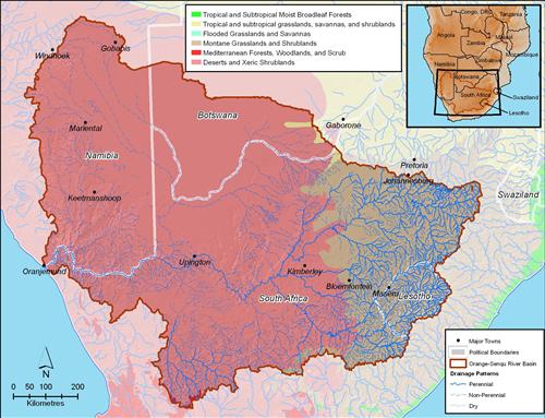
Generally, the western basin is characterised mostly by desert shrublands, whereas the east is dominated by montane grasslands and shrublands.
The highlands of Lesotho support alpine vegetation consisting of climax heather communities containing mostly low, woody species, which are interspersed with alpine grasses at the highest altitudes. The habitat is predominantly grassland in the high-lying areas while at lower altitudes, mixed sour grassveld occurs which extends in the westerly direction to the Nama Karoo.
A series of karooid vegetation types characterise the middle and lower Orange River catchment, including the Fish River tributary in Namibia, ending ultimately in the Succulent Karoo from the Richtersveld to the coast. The Nossob / Molopo catchment in Namibia and Botswana mainly drains through the Southern Kalahari, with this area being covered by sparsely distributed desert shrubs.
These biomes are described in more detail in the Ecology and Biodiversity chapter.
Landcover in the Basin
Aligned with the above Biome distributions, the Orange-Senqu River basin is dominated by four primary land cover types:
- Grassland (64%)
- Bush (18%)
- Bare ground (10%)
- Cultivated (7%)
Other land cover types include: urban, wetlands, trees and mining.
The majority of the southern and western parts of the Orange-Senqu River basin are covered by grasslands and bare ground, due to the more arid climate. North/central parts include a mixture of bush and grassland and the eastern part of the basin, including large sections of the Vaal sub-basin are covered by cultivated lands.
The chart and map below illustrate the landcover classifications and distribnution respectively. at 64 % grassland dominate the landscape, with bush at 18% and bareground at 10%.
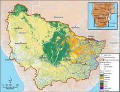 Primary landcover of the Orange Senqu river Basin Source:Hatfield 2009 after Teralimage 2008 ( click to enlarge ) |
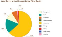 Proportion of Landcover types in the Orange- Senqu River Basin Source:Hatfield 2009 ( click to enlarge ) |
Explore the land cover of the sub-basins of the Orange-Senqu River basin using the Geography Maps Interactive Component, or view the land cover map in Google Earth.
![]()