|
Geography:
River Basin and IWRM |
The Role of the River Basin in IWRM
Drainage basins, also called catchments or watersheds, include all the land that drains into a river channel, from its source to its mouth (Dunne and Leopold 1978).
The Global Water Partnership and International Network of Basin Organisations (INBO) publication A Handbook for Integrated Water Resources Management in Basins (2009), recognises the river basin as the practical hydrological unit of choice for Transboundary Water Management (TWM) and Integrated Water Resources Management (IWRM). While this approach considers the basin boundary over political boundaries, it provides the basis for holistic management of the resource. While this is a logical approach from a hydrological perspective, it creates a whole new set of challenges with respect to hydro-politics, resource sharing and data acquisition and management.
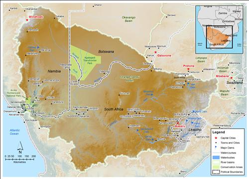
The Orange River basin is shared by four countries - Botswana,Namibia, Lesotho and South Africa. While each of these countries may have different requirements and agendas with respect to the river, they must all cooperate to meet their objectives.
Geographical Challenges Presented by IWRM
Two specific challenges that the River Basin Approach creates with respect to water resources management, especially in the Orange-Senqu River basin are data collection and harmonisation, and groundwater resources.
Data
In a transboundary setting, most data are collected at national level, and with the exception of a few rare cases, have been gathered for different periods of time, using different methods and stored using different approaches and technologies.
The River Basin Approach requires basin-wide data to be collected in the same formats and to the same standards. This requires that data is collected and collated uniformly or for an additional basin-wide programme to be put in place, which can be an expensive under-taking.
Groundwater
As the River Basin Approach uses a surface water unit as the basis for planning and management, it does not always encapsulate all of the groundwater resources, as groundwater aquifers do not necessarily conform to the same boundaries as surface water resources. While some transboundary (across national borders) aquifers may exist within the basin, some may transcend the surface water basin boundary. Therefore, considerations must be made for inter-river basin groundwater flow, particularly with respect to development of water balance budgets.
![]()