|
Geography:
Geomorphology |
Geomorphology is the study of the origins of landscape as it is seen today and is considered to be the science dealing with the relief of the earth and the drivers that create this relief, such as geology and soils. It is a combination of geology, physics, chemistry, biology and history, resulting in the evolution of complex geographic and topographic environments (Anderson 2008).
Many drivers impact on the geomorphology of a river basin and this part of the Geography Chapter provides a brief overview of the key drivers.
Basin Geomorphology
Within this section, the Geomorphology of the Orange-Senqu is described in terms of :
- Relief
- Geology
- Soils
- Mineral Reserves
As can be seen from the map below (left), the Orange-Senqu River basin in corporates the three dominant geomorphological provinces of South Africa - the Highveldt, Middleveldt and Lowveldt. Futher west, portions of the Plateaut of South West Africa and the Kalahari Basin, in Namibia and Botswana.
The region is transected by a geomorphological feature known as the Great Escarpment, which extends from the western edge of the Namibia and Angola plateaux, right around South Africa and north to the Zambezi River in Zimbabwe. This feature varies in height, reaching its maximum in the Drakensberg Mountains of South Africa at approximately 3 299 m above sea level. This is illustrated in the map below (right). As can be seen from the map below, the Orange-Senqu River basin lies almost entirely within the Great Escarpment.
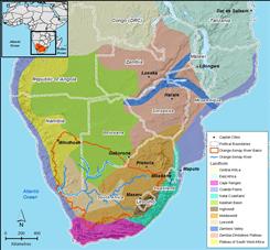 Geomorphological Provinces of southern Africa. Source:After Bridges,1990 ( click to enlarge ) |
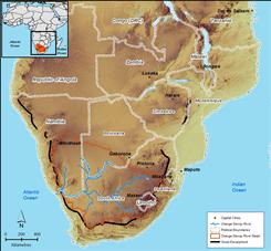 The Great Escarpment of southern Africa. Source:After Bridges,1990 ( click to enlarge ) |
![]()