|
Ecology and Biodiversity:
Wetlands |
The distribution and availability of water resources in the Orange-Senqu River basin is closely linked to the presence of wetlands. According to estimates provided by the World Resources Institute (WRI 2008), wetlands cover approximately 0,8% of the total basin area. These floodplains and reservoirs provide important water storage capacity. Wetland habitats, productivity and biodiversity, as well as ecological processes, depend on the availability of water.
ORASECOM is currently finalising a study on the management of wetlands: ‘Protection of Orange-Senqu Water Sources – Sponges’. This study aims to:
- Provide useful information relevant to the protection of Orange-Senqu source areas
- Identify actions – technical, economic and institutional – which could address these problems
- Develop a preliminary action plan, which could include further studies and investigations (ORASECOM 2008c).
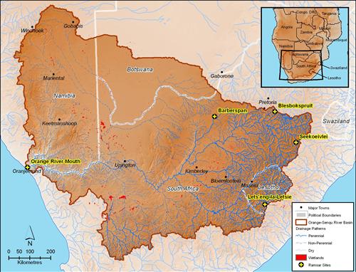
The main wetlands of the Orange-Senqu River and Ramsar sites are illustrated below. The Senqu sub-basin contains the highland sources of springs and rivers, in wetlands commonly called sponges. Stagnant water bodies like marshes, and exposed water bodies, occur in the gentle slope sections of the various rivers, dams in the main stem of the Orange-Senqu River, and at the river mouth.
The Convention on Wetlands of International Importance was adopted in the Iranian city of Ramsar in 1971 and is generally known as the Ramsar Convention. It is an intergovernmental treaty that provides a recognised framework for national action and international cooperation in the conservation and wise use of wetlands and the natural resources associated with them (Ramsar 2009).
According to the “Ramsar Convention” wetlands include lakes and rivers, swamps and marshes, wet grasslands and peatlands, oases, estuaries, deltas and tidal flats, nea-shore marine areas, mangroves and coral reefs, and human-made sites such as fish ponds, rice paddies, reservoirs, and salt pans.
One of the fundamental concepts of the Ramsar convention is Wise Use, which is defined as "the maintenance of their ecological character, achieved through the implementation of ecosystem approaches, within the context of sustainable development".
Ramsar Sites in the Basin
Five Ramsar sites have been identified and accorded conservation status in the basin:
-
The Orange River Mouth drains into the Atlantic Ocean, only occasionally when it is not blocked by sand-bars. The 2 000ha site was named a Wetland of International Importance (according to the Ramsar convention) in 1991 and is home to up to 60 bird species, an appreciable number of which are Red-listed species (http://www.iucnredlist.org/), including the Cape Cormorant, Damara Tern and Hartlaub’s Gull. (Bethune 2007; UNDP-GEF 2008). The Orange River Mouth Ramsar site is shared by Namibia and South Africa.
- The second Ramsar site is the Seekoeivlei Nature Reserve, as the largest wetland in the African Highveld it supports a large number of local and migratory birds (SAWCP 2009a). The Nature Reserve is found in the floodplain that drains into the Klip River and eventually into the Vaal River.
- The Barberspan Nature Reserve covers 3 118 ha of which 2 000 ha is water. The Barberspan is the largest of a series of grass pans in the fossil Harts River basin. Other pans exist in the area but are non-perennial (SAWCP 2009b). 320 bird species have been spotted at the pan and it is important to the maintenance of several rare and endangered animals and plants.
- Lets'eng-la-Letsie is a source of the Quthing River in Lesotho that contributes 3% of the total flow to the Senqu River (DWA 2003). The Lets'eng-la-Letsie wetland consists of a man-made lake resulting from a small dam built on the Mohlakeng River. The area was declared a protected area in 2001 because of its importance as a tributary to the Orange-Senqu River system, its high natural mountain biodiversity and the relatively undisturbed state of the high mountain wetland.
- Blesbokspruit is one of the larger wetlands found in the highveld region of South Africa. Situated very close to the Orange-Senqu River basin boundary, near the town of Springs in Gauteng Province, Blesbokspruit is approximately 1600 m above mean sea level. Blesbokspruit is seen as having a high conservation value, specifically due to its water purification functions in a region affected by industrial and domestic effluents.
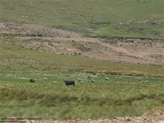 Fanana Sponge in Lesotho. Source:Lesotho Water Commission 2003 ( click to enlarge ) |
The Orange River Mouth – a Ramsar Site Under Threat
The Orange River mouth is a designated Ramsar site, a protected wetland and a microcosm of saline marshes. Until a few decades ago it offered a rich diversity of crabs, snails and fish. More than 50 species of migratory birds used to find good food here, and an ideal place to rest.
For millions of years, the natural rhythm of the pulsing river ensured the existence of the marshes. In dry winters the ocean’s tides raised their salinity, while in summer the Orange River’s strong floods reduced it. Plants and animals lived by this rhythm for millions of years, but a half-century ago it was destroyed by the large dams built in the Orange’s upper reaches. The river’s flow became more or less uniform, and this had fatal consequences.
Sediments from the south, brought in by the Benguela Current, now obstruct the river mouth with high sandbanks. The river stagnates behind them. As a result the water in the estuary wetland has increased in salinity and many of the more sensitive animal species have disappeared. Similarly the number of migratory birds that stop over has dropped dramatically. Since 1995, because of this widespread destruction of the saline marshes, the area has been placed on the so-called “Montreux list” of endangered wetlands.
Both Namibia and South Africa are committed to protecting the Orange River mouth, but thus far they have not acted with conviction, hence there has been little change. Occasional removal of sandbanks by excavators may prevent the flooding of the Oranjemund golf course, but it does little to help the wetland ecosystem. Artificial flooding pulses released from the Vanderkloof Dam, 1 400 kilometres upriver, have no effect at all. By the time they reach the mouth they have diminished to waves that are barely noticeable.
The only hope for the wetland is the plan to build a new dam on the Orange, 350 kilometres upstream, at Vioolsdrift. This dam would result in even less water reaching the mouth, but the flooding pulses released from it could overcome the problem of sandbanks in the river mouth. The biological diversity of the saline marshes would then have a chance to recover.
![]()