|
Climate and Weather: Climate of the Orange-Senqu River Basin:
Climatic Patterns and Variability in the Orange-Senqu River basin |
Several aspects of the hydrologic cycle are critical to climate in the Orange-Senqu River basin:
- Temperature
- Precipitation
- Evaporation
- Evapotranspiration
Temperature
Average temperatures range from approximately 12°C in the Lesotho Highlands to more than 22°C in the Richtersveld region near the Orange River mouth. Extreme temperatures in excess of 50°C can be experienced along the banks of the lower Orange River in South Africa. Temperatures below –10°C are common in the winter months in the Lesotho Highlands, with some areas experiencing more than 200 days with frost per year
The maps below show the average temperature variation for January and July. These represent the hottest and coldest months in the basin.
Precipitation
With a mean annual precipitation of approximately 400 mm, the Orange-Senqu River basin is considered well-watered by southern African standards (DWAF 2008). However, its water resources are nonetheless finite and are affected by severe climatic variability. This situation is exacerbated by the already-high and increasing demands for water from growing populations and economies.
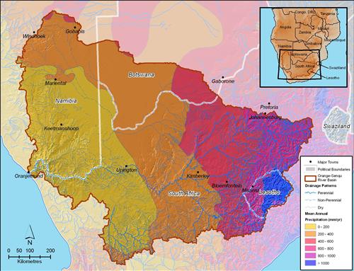
The rainfall season for most of the Orange-Senqu River basin normally begins in September and rainfall slowly increases in intensity and frequency through to February. The mean annual rainfall distribution is shown below.
The mean annual precipitation at the summit of the Maloti-Drakensberg escarpment in Lesotho is 1 600 to 1 800 mm, decreasing sharply westward to only 45 mm at the Orange River Mouth. Furthermore, rainfall in the western part of the basin is highly variable.
Variability of precipitation in low-rainfall regions is a critical factor in understanding the climate, as it helps explain the natural year-to-year situation and to an extent the scarcity of water resources. Periods of drought were prominent in the late-1960s, mid-1980s, 1990s and beginning of 2000s, whereas above-normal rainfalls were received in the mid-1970s, at the end of the 1990s and in the extremely wet year of 2011.
The map below shows the average annual precipitation patterns for the Orange-Senqu River basin.
Evaporation
High average temperatures across most of the basin result in high evaporation rates, especially in the arid and semi-arid west of the Orange-Senqu River basin. This, combined with low rainfall, results in an average water deficit of approximately 1,9 m per year in the middle reaches of the Orange River and approximately 2,6 m per year in the western parts of the lower Orange-Senqu River basin.
Evapotranspiration
Mean annual evapotranspiration at the source of the Senqu River in Lesotho is approximately 1 200 to 1 400 mm. This increases to an average of 1 400 to 1 800 mm in the Upper and Lower Orange and yet higher to over 2 000 mm in the Fish River system, Namibia. The map below shows the mean annual evapotranspiration for the Orange-Senqu River basin.
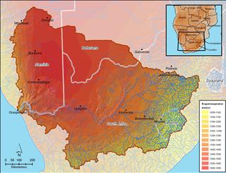 Evapotranspiration across the Orange-Senqu River basin. Source:Hatfield 2009, after UNDP 2008 ( click to enlarge ) |
![]()