|
Socio-economics in the Basin: Sustainable Livelihoods:
Ecotourism |
Parks and nature reserves are important elements of community-based natural resource management and employment, including Ecotourism. Across southern Africa, reserves and parks offer an alternative livelihood to subsistence farming. People are able to find work near their homes, eliminating the need to travel to the urban centers for work. In the Orange-Senqu River basin there are quite a few protected areas.
These areas are significant tourist destinations, shown in the map below; they contribute to the national and local economies of all four countries. Some example – from the source to the river mouth – are presented on this page.
Lesotho
Lesotho, on the one hand, has to meet serious environmental challenges like soil erosion. On the other hand this country is a paradise of National Parks and nature reserves.
Sehlaba-Thebe National Park
This area was proclaimed a “Wild-life Sanctuary and National Park” and therefore a protected area on 27 February, 1970. It is situated in Qacha’s Nek, has an area of 6 475 ha and lies at an altitude between 2 300 and 2 500 m. It has subsequently been established that the Park contains several important rock art (archaeological) sites.
Masitise Nature Reserve
This nature reserve also includes an archaeological site and historic mission cave house. It is proclaimed a National Monument in the Quthing District. It is a small reserve of about 20 ha, 3 ha of which is thickly wooded.
National University of Lesotho (Roma Campus)
This university campus was declared a bird sanctuary by the council of the University on 3 April 1965. It has an area of about 95 ha and is situated in the Highveld Grassland Zone, but the area has been modified by introduction of exotic trees and the creation of water areas.
There are other initiatives to include some important areas of biodiversity into the official national listing of national parks and nature reserves. Two such areas are along the border with South Africa: the Maloti Drakensberg Area and the Letšeng-la-letsie Protected Area in southern Lesotho.
The Maloti-Drakensberg Transfrontier Conservation and Development area Programme
This is a World Bank-financed project intended to aid conservation of biodiversity values in the Maloti Drakensberg area, and to help development of the people in the adjacent areas along the border between Lesotho and South Africa. The programme is a joint initiative of the Governments of Lesotho and the Republic of South Africa. It is a transboundary conservation and development programme aimed at establishing protected areas while promoting sustainable tourism in the Maloti Drakensberg mountains.
The World Bank has committed about R62 million towards the creation of a massive transfrontier conservation and development programme encompassing areas in the Eastern Cape, KwaZulu-Natal, Free State and Lesotho. The five-year old Maloti-Drakensberg Transfrontier Conservation and Development Programme incorporates existing parks and conservation areas and aims to preserve the important biodiversity of the region while contributing to community development through ecotourism initiatives (Zunkel 2003).
The Maloti-Drakensberg Mountains are an extremely important water catchment area with the alpine and montane grasslands hosting a myriad of wetland systems. These fragile systems are crucial to the delivery of one of the areas most important ecosystem services: perennial flows of high quality water. With this area being one of the few in southern Africa where the long-term annual average precipitation exceeds the long-term annual average evaporation, it is easy to understand its importance as a water catchment importance. The Lesotho Highlands Water Scheme has been well publicised and is completely dependent on the water that drains out of this area into rivers such as the Senqu and Mokhotlong. The bulk of KwaZulu-Natal's water flows from these mountains in rivers such as the Tugela, Mkhomazi, Mzimkulu and Mzimvubu (Zunkel 2003).
Letšeng-la-letsie Protected Area
This is an important wetland area in southern Lesotho. Efforts are currently underway to engage support for designating the area a protected site. The Conserving Mountain Biodiversity in Southern Lesotho project provides financial support. The project is financed by the Global Environment Facility (GEF) and is implemented by the United Nations Development Programme (UNDP). The National University of Lesotho has undertaken a comprehensive Environmental Impact Assessment for the establishment of a protected area at Letšeng-la-Letsie
Katse Botanical Garden
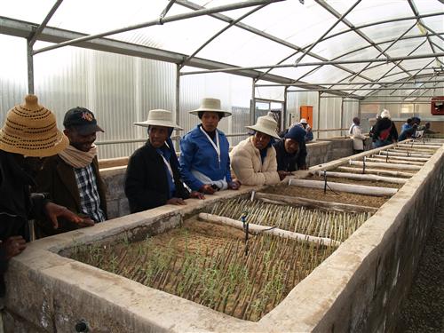
The “Lesotho Highlands Water Project” has significant impact on the environment in the mountains of the country. It is very important that this unavoidable impact is compensated by the creation of nature reserves and other measures. Accordingly the government of Lesotho has proclaimed several wetlands in the mountains as protected areas, and the “Lesotho Highlands Development Authority” (LHDA) has created a miniature paradise on a hillside above Katse Dam: Katse Botanical Garden – one of the highest-lying botanical gardens in the world.
The establishment of Katse Botanical Garden was an explicit wish of the people here and is included in the project agreement. The aim was to preserve the flower, shrub and herb diversity of the regions that were being flooded by the LHWP, so that people can continue using these plants and can protect the natural heritage they represent. There are many examples for this fascinating heritage:
There is the striking symmetry of the “Boophone” (Boophone disticha), an amaryllis plant with long leaves that radiate outwards from its bulb like a palm’s. Although it is highly poisonous – its neurotoxin causes visual disturbances, hallucinations and paralysis, and was used by the San for hunting – it can also be used for beneficial purposes by traditional healers, so-called sangomas.
Less dangerous are Haemanthus humilis, also from the amaryllis family, and Brunsvigia grandiflora, occurring only in mountainous regions. The latter produces a magnificent pink flower forming an expansive, fine-leafed bouquet. The variety of aloes in the garden – from “aristata” to “broomii” and “pratensis” to the “maculata” with its poisonous seeds – is also impressive.
People still living around Katse Dam want to continue using the region’s medicinal plants. So, they buy seeds or cuttings for a small fee from the botanical garden – the reasons being that the small health centre in Katse is not always open and the nearest hospital is an hour away in Thaba-Tseka. This is why people like to have plant remedies at home.
Helichrysum orodatissimum, for example, is a herb that alleviates headaches and flu, and its aromatic smoke is an insect repellent and aids a quiet night’s sleep. The pineapple lily (Eucomis autumnalis) helps in treating diarrhoea and speeds up the healing of broken bones.
Quite a number of herbs found in the Katse botanical garden have found their way into the global pharmaceutical industry. For instance, Pelargonium sidoides is used to make medication for asthma and bronchitis. Another example is Xymalobium undulatum, which the Xhosa use as a basis for their broadly applicable “Uzara-medicine”. Doctors in Europe prescribe extracts from the plant for stomach cramps.
Apart from that, visitors of Katse botanical garden can rest under the wide canopy of a bush called “Moshoeshoe’s Birth” (Heteromorpha aborescens). By tradition BaSotho elders like to hold their meetings in the shade of such a bush, which can grow as tall as a tree. Along with the Aloe polyphylla this bush is one of Lesotho’s national plants.
On a hillside with phantastic views down to Katse Reservoir a training centre and cafeteria with enchanting layouts are under construction. This botanical garden has the potential to become a proud example for sustainable eco-tourism and job creation – if the responsible authorities nurture and maintain it to the best of their abilities.
For more information oni Katse Botanical Garden, please visit the Lesotho Highlands Water Project website.
South Africa
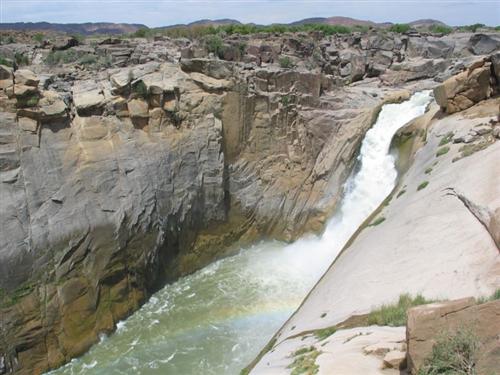
Augrabies Falls Nature Reserve
Aukoerebies is a Khoi name for "the place of the Great Noise", where the Orange River thunders its way 60 m downward in a spectacular waterfall, downstream of Uppington. Augrabies Falls are arguably the most impressive waterfall along the Orange River. The 28 000 ha of the Nature Reserve, on both the northern and southern banks of the Orange River, provide a sanctuary to diverse species from the very smallest succulents, birds and reptiles to Springbok, Gemsbok and the endangered Black Rhino. Careful development has made Augrabies Falls a very attractive eco-tourism destination – providing a considerable amount of jobs in the park administration, hotels, lodges and restaurants.
South Africa/Botswana
Kgalagadi Transfrontier Park
The Kgalagadi Transfrontier Park was established in 1998 as a cross-border merger of two national parks in the southern Kalahari desert, one in Botswana and the other in South Africa. The park contains no fences or border controls, but the countries apply different approaches to park management.
Botswana’s 2.8 million park hectares exist in a largely natural state. You need four-wheel drives to navigate the sparse network of roads, and camping is the only option for accommodation. In contrast, the South African side consists of nearly 1 million hectares sandwiched between the Nossob and Auob rivers which are normally dry and come together at Twee Rivieren. There is plenty of infrastructure including dozens of artificial water holes, where a dazzling cavalcade of animals takes refreshment at dawn. There are picnic sites and comfortable camps with permanent accommodation, and the chief roads are fine for ordinary passenger vehicles.
Even during the rainy season the wide riverbed of the Auob, fringed by red dunes, can almost always be used as a road. During the rainy season it is speckled with yellow, purple and red flowers emerging from a carpet of lush green grass. Camel thorn trees, some of them 300 years old, are dotted here and there. The branches hold huge communal weaver nests the size of cupboards, each one surrounded by hundreds of small birds all fluttering and chirping.
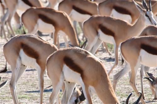
Cruising through the wide river plain the visitor will spot an amazing amount of animals. There are eland, hartebeest and herds of graceful springbok grazing within seas of flowers. Further you can see gemsbok bulls in noisy duels for pre-eminence, each one slashing with horns that are a metre long; and then long-haired wildebeest, their calves hugging their sides.
The necks of giraffes often appear behind a hill, while they are enjoying a meal among the high branches of a tree. In the afternoon, near a waterhole, jackals might flit past you – while secretary birds, surrounded by smaller water birds, stalk along the fringes of a pond. To see leopards or even lions, one has to be lucky. The authorities say that 150 lions roam through the South African section of the park and 400 in Botswana’s.
Kgalagadi means “land of thirst”. The average annual rainfall is just 200 millimetres and the plants and animals of this park normally depend on groundwater. The water quality in the boreholes varies. In one place the water may be sweet, in another brackish. At the same time different animals have different preferences. Certain antelope species are indifferent to what water they drink, most birds like their water sweet. But even in dry years, the animals of the Kgalagadi Transfrontier Park always find enough water. If necessary, they eat wild melons, “tsammas” (Citrullus lanatus), prickly yellow “springbok cucumber” (Indigofera alternans) and other fleshy succulents.
South Africa/Namibia
/Ai-/Ais/Richtersveld Transfrontier Park
In 2003 an agreement between South Africa and Namibia established the /Ai-/Ais/Richtersveld Transfrontier Park. The Park covers 6 222 km² and lies in two protected areas on both sides of the Orange River that marks the border between the two countries: the South African Richtersveld National Park and Namibia’s /Ai-/Ais Hot Springs Park, which includes the Fish River Canyon (often likened to the Grand Canyon in the USA).
The arid area of this Transfrontier Park is characterized by a unique and impressive variety of plant species, which makes the park an undisputed biodiversity "hot spot". There are 5 000 or so plant species in the park. These include one third of the world’s succulents, among them numerous aloes and quiver trees. Apart from that, there are gemsbok, kudu and leopards; many monkey species and tortoises; puff adders, black spitting cobras and scorpions (these last make it unwise to walk barefoot at night). The fabulous rock formations found in the park include arches, columns and amphitheatres formed out of granite, gneiss, quartzite and sandstone.
To see all this, however, in an extremely rough terrain one needs a four-wheel-drive vehicle and the assistance of local people, who are at home in this region. Accordingly there is an unusual feature of the Richtersveld Park that combines eco-tourism with strong involvement of the local population and thus tries to make eco-tourism also socially sustainable:
South African National Parks (SANParks) doesn’t own the park, but leases the land from the local community. SANParks pays a fee into a development fund, which benefits the Nama community living here. At the same time representatives of the community assist in managing the park. The major part of this community lives in the town of Kuboes.
Kuboes is located 40 kilometres southeast of Sendelingsdrif within a rocky desert solitude. A town,attractively laid out and very different from the large clusters of uniform low-cost housing found elsewhere in South Africa: Pretty houses painted in fresh pastel shades, inviting guest houses and the imposing, freshly whitewashed Rhenish Church, built in 1893 under pastor Johan Hein who worked in Kuboes for over 50 years.
The town’s streets and squares are spotlessly clean and small trees have been planted in front of most houses, in defiance of the surrounding aridity. Some 2 000 people live in Kuboes, among them neatly-dressed boys playing soccer and young girls wearing make-up, T-shirts and jeans and playing with cell phones – very much like Cape Town.
Gert Links, the official manager of the Richtersveld Conservancy, is an elderly man, calm and modest, wearing a simple green polo shirt. While looking for old documents on his computer, he smiles almost scornfully and talks about the negotiations to establish the Richtersveld Park, which took 18 years. “At every turn, the apartheid government tried to hoodwink us. But we stuck to our guns.”
According to the agreement signed on 20 July 1991, the Nama receive a rental of 80 000 Rand per year. They are represented on the Park’s supervisory board and are permitted to graze up to 6 600 animals, though horses, cows and donkeys each count for seven animals because of their higher impact. Diamond mining is also permitted in the park and could provide employment for many Nama, but none of the mines are currently active.
“We want to renegotiate the agreement,” Gert Links says. “The rental no longer has much worth and if we’re ‘co-managers’ of the park, we’d like to have a bigger say in the management of the park’s budget.” The biggest challenge facing the authorities of Kuboes is the struggle to create employment. “Without work, humans degenerate physically, mentally and morally.”
Gert tries to ensure that when the Richtersveld Park has job vacancies they are filled by local Namas. Not only that, but he advertises Kuboes to tourists as the gateway to the park; and he urges the mining company Trans Hex to employ local workers. The budget allocated to Kuboes for job creation is shared by 100 of the very poor, who each work two days a week. Clad in orange-coloured overalls, they sweep the streets, help the elderly or assist the pastor maintain the church.
Meanwhile Willem Hans, a slim, grey-bearded man who wrinkles when he smiles, has committed himself to reviving Nama culture, which was a casualty of the apartheid era. “Back then we were only permitted to speak Afrikaans at school,” he says. “Because of that, neither my wife nor my children speak Nama. Even today, the only books available in our language are the Bible and a hymnbook. In church we have begun singing in Nama. On top of that, we have the only elementary school in the world, where children are learning Nama and reading traditional poems and stories in our language.”
Adults in Kuboes are learning the language of their forebears as well, and they get to practice their traditional music in a choir and a dancing group. As Willem continues, “Recently a camera crew from Johannesburg visited here and recorded our dances and songs for a documentary.”
Namibia
The Sperrgebiet National Park
There is still diamond mining going on in a small portion of the “forbidden area” (Sperrgebiet) in the extreme southwest of Namibia. And as yet only a small part of the mining area has been fully rehabilitated. The responsible company, Namdeb, is busy attending to serious scars in the forbidden area, which in 2008 was proclaimed as the Sperrgebiet National Park. This is designed to attract eco-tourists and to supplement the neighbouring Ai-Ais Richtersveld Transfrontier Park. Besides offering secluded beaches, towering dunes and vast, stone-strewn plains it will hold a multitude of succulents and animals.
A few years from now, visitors will marvel at 8 000-year-old San rock carvings at Daberas. Thanks to joint initiatives by Namdeb and international scientists they will be able to explore fossil sites where elephants, crocodiles and early forms of dogs used to roam. Many visitors will want to experience history through the sand-swept and wind-blown ghost towns, where one can still find beer and whisky bottles left behind by German colonists, or read gravestones that hark back to a forgotten era. Wandering among thousands of gravel heaps, they will be able to empathise with the hardships experienced by the early diamond diggers who had to live on starvation wages.
Julien Cloete, an environmentalist with Namdeb, sees lots of potential for tourism in the Sperrgebiet National Park, and for good reason. The region already has a good basic infrastructure including 100 kilometres of tar road, 750 kilometres of dirt roads, drinking water and electricity supply lines. It also boasts fibre-optic cabling that offers modern communication options. Oranjemund, close to the Atlantic coast and rich in trees, offers an attractive urban centre at the park’s edge. It has the makings of a resort town complete with shops, a modern hospital and what may well be Namibia’s best primary school. Its sports facilities include an 18-hole golf course. Best of all, many of the people living here are well educated and have professional skills, which qualifies them to run the Oranjemund of tomorrow. For the moment Oranjemund is only accessible with special permission, but it is rapidly transforming into a normal town and will soon be open to all. A road to the north is being built.
Namibia/South Africa
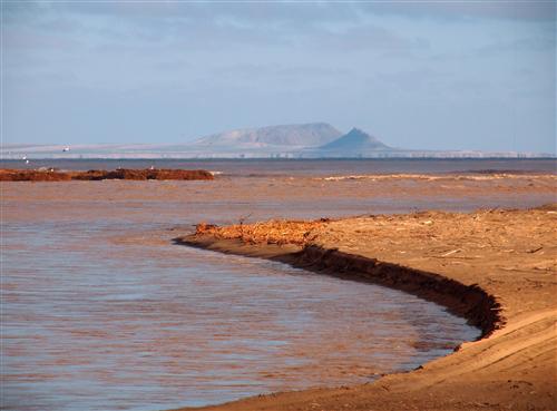
The Orange River Mouth
The Orange River Mouth is a transboundary area of extensive salt marshes, freshwater lagoons and marshes, sand banks, and reed beds, shared by South Africa and Namibia. The Orange River Mouth is a Ramsar site, but due to degradation in this important wetland area, it has now been placed on the Monreaux Record. The pressures placed on the wetland ecosystem are related to various land uses such as the adjacent diamond mining activities and flow regulation of the Orange River as a result of dam construction upstream. The area is important for resident birds and for locally migrant waterbirds.
For more information on the River Mouth and the Convention on Wetlands of International Importance (Ramsar), please see the Wetlands section to learn more about the wetlands of the basin.
![]()