|
Water Infrastructure: Irrigation:
South Africa |
The total combined irrigated area for the Vaal and Orange basins in South Africa is approximately 300 000 ha (FAO 1997). Water use for that area is 2 779 Mm3/ yr and with a potential use of 4 300 Mm3/yr by 2010 the irrigation potential is estimated at 352 500 ha.
Orange WMAs
The irrigation schemes in the Upper and Lower Orange WMAs mainly consist of a series of weirs and canals, providing water to riparian farmers on both banks of the Orange River.
The main irrigation schemes in South Africa are:
- Douglas Irrigation Scheme
- Boegoeberg Irrigation Scheme
- Upington Irrigation Scheme
- Kakamas Irrigation Scheme
- Onseepkans Irrigation Scheme
- Namakwaland Irrigation Area
- Vioolsdrift and Noordoewer Irrigation Scheme (RSA and Namibia)
- Middle Orange Irrigation Area (Modder/Riet Irrigation Scheme)
Douglas Irrigation Scheme
Douglas Irrigation Scheme is located at the downstream end of the Vaal River. This scheme receives water from the Vaal River, supplemented with releases from the Orange River via the Orange-Vaal Transfer Scheme.
Middle Orange Irrigation Area
The Middle Orange Irrigation Area comprises riparian irrigators from Hopetown to Boegoeberg Dam. The area irrigated from Marksdrift to Boegoeberg Weir amounts to approximately 15 434 ha. Irrigators in this area are not part of a formalised scheme with a common supply system. Irrigators abstract water directly from the Orange River individually basis and are supported with releases from Vanderkloof Dam.
Modder/Riet Irrigation Scheme
The Orange-Riet canal is supplied with water from Vanderkloof Dam via the Vanderkloof Canal. An area of approximately 21 750 ha is irrigated and includes the Riet River settlement, developments along the Orange-Riet Canal, Scholtzburg and Ritchie Irrigation Boards and the lower Riet River Irrigation Board. The first 74 km of the canal has a capacity of 16 m³/s while the last 38 km has a capacity of 13 m³/s. Provision has been made to increase the capacity of the canal to 24 m3/s.
Boegoeberg Scheme
Boegoeberg Dam is located about 150 km upstream of Upington in the Orange River, and is the major structure supporting the releases to the Boegoeberg irrigation area. Sedimentation has decreased the capacity of the reservoir from its original 34,7 Mm³ to only 20,7 Mm³. The Boegoeberg Canal is a 172 km long canal on the left bank with a capacity of 9,76 m³/s. Water for irrigation is supplied to the Noord-Oranje Irrigation Board as well as to the Gariep Settlement. The Boegoeberg Canal on the left bank also supplies water to the Rouxville West Scheme.
Keimoes Canal Irrigation Area
Keimoes irrigation area consists of various Irrigation Boards, each with its own diversions from the Keimoes Canal which obtains its water from the Orange River. The scheduled area for the Boards abstracting water from canals is 5 089 ha and 296 ha is scheduled with water abstraction from the river.
Onseepkans Irrigation Area
Onseepkans irrigation area is supplied through a canal on the left bank of the Orange River. The capacity of this canal is unknown, but it supplies water to 314 ha of irrigation land.
Namakwaland Irrigation Area
The water for the Namakwaland Irrigation Area is abstracted from the Orange River. Water is released from VanderKloof Dam to supply users in this area. The scheduled area is about 2 439 ha.
Vioolsdrift and Noordoewer Irrigation Area (RSA and Namibia)
Vioolsdrift and Noordoewer irrigation areas are supplied through a canal system fed by the Vioolsdrift Weir on the Orange River. The scheduled irrigation area for Vioolsdrift (RSA) amounts to 600 ha and for the Noordoewer (Namibia) area, 284 ha. This scheme has been transferred to, and is operated by, the Vioolsdrift and Noordoewer Joint Water Authority.
Middle Vaal WMA
The Schoonspruit and Klerksdorp irrigation schemes are both located in the middle Vaal WMA, abstracting water from the Schoonspruit Eye, Kalk Dam, Elandskuil Dam, Rietspruit Dam and the Johan Neser Dam. Almost half of the water generated in the Schoonspruit Catchment originates from the Schoonspruit Eye, which is fed by dolomitic aquifers.
The Schoonspruit Irrigation Scheme
The scheme is located close to Ventersdorp and receives its water from the Schoonspruit Eye, Elandskuil Dam and Rietspruit Dam. A weir has been built to divert the Eye’s water into a canal on the right bank of the Schoonspruit River. This canal conveys the water to the Ventersdorp Municipality and irrigation areas located further downstream along the canal system.
The canal crosses the Schoonspruit River just downstream of the Kalk Dam, where there is a structure that can "reject" excess water from the canal into the Schoonspruit River, and also allow water to flow into a canal on the left bank of the Schoonspruit. This canal supplies irrigation water down to the Rietspruit Dam (507 ha) and supplies via the Elandskuil pipeline to the Elandskuil Dam and canal on the Right Bank of the Schoonspruit River. Water from the Rietspruit Dam and Elandskuil Dam irrigates 1 280 ha and 648 ha respectively.
The Klerksdorp Irrigation Scheme
The scheme was developed around the Johan Neser Dam. The major purpose of the dam is to provide water for irrigation. With time, less water has been available, mainly as a result of upstream developments and increasing groundwater abstractions, utilising water from the dolomite aquifers feeding the Schoonspruit Eye. The dam is operated by the Klerksdorp Irrigation Board and currently the average area irrigated is much smaller than the scheduled area. Some irrigators abstract water directly from the dam basin and directly from the river just upstream of the dam. Water is also supplied to irrigators via a canal system, through a pipeline, and by means of releases directly into the river downstream of the dam.
The Sand-Vet Irrigation Scheme
The Sand-Vet Irrigation Scheme comprises an area of 11 708 ha. Centre pivots are used on almost 90% of the irrigated land; a few farmers practice flood type irrigation for growing diverse crops such as wheat, maize, sunflower and vegetables.
The Sand-Vet Irrigation Scheme includes the Erfenis Irrigation Scheme and the Allemanskraal Irrigation Scheme, currently supplied with water from the Erfenis Dam and Allemanskraal Dam, respectively. Erfenis Dam supplies water for the irrigation of 5 489 ha; any excess water at the canal tail end flows into the Vet River. Downstream of the confluence of the Sand and the Vet River, another 1 297 ha of irrigation is mainly supplied directly from the Vet River. For the Allemanskraal Scheme, water is diverted from Allemanskraal Dam into the main canal. This canal then splits into two separate canals downstream of the dam, supplying water for irrigation on the left and the right banks of the Sand River. Any excess water at the tail ends of these canals flows back to the Sand River.
Lower Vaal WMA
The Vaalharts Irrigation Scheme, the largest in South Africa, is the main user in the Lower Vaal WMA and is supplied with water from Bloemhof Dam. Water is released from Bloemhof Dam into the Vaal River, which is then diverted into the Vaalharts main canal at the Vaalharts Weir. Releases from Bloemhof Dam are also used to supply water to Kimberley, the Vaal Gamagarra Water Supply Scheme, and irrigation along the Vaal River between Bloemhof Dam and the confluence of the Vaal and Riet Rivers. Releases from Bloemhof Dam sometimes do not meet the requirements of the Vaalharts Scheme and other irrigators along the Lower Vaal. At such times Bloemhof Dam is supplemented by releases from Vaal Dam.
The Vaalharts canal system consists of a main canal of length 19 km and capacity of 48 m3/s. This canal travels along the right bank of the Vaal River for about 13 km before splitting, the main section heading northward into the Harts River Catchment. The smaller branch, which continues along the bank of the Vaal, is called the Klipdam-Barkley Canal. The main canal splits again into the West Canal (length 21 km, initial capacity 6 m3/s), and the North Canal (length 60 km, initial capacity 39 m3/s). All these canals are concrete lined. The scheme also has an extensive drainage system to deal with return flows and storm water. Approximately 442 Mm3 is supplied to the scheme annually.
Based on studies conducted in the Lower Vaal WMA, it seems that a large portion of irrigation which utilises the Vaalharts Scheme is unlawful, and ought to be prevented through identification and license applications.
Spitskop Dam sub-system
Spitskop Dam was constructed to supply irrigators along the lower Harts upstream of the Vaal confluence. The dam is downstream of the Vaalharts Irrigation Scheme and therefore substantial return flows seep into the dam. The dam is currently utilised only to supply irrigation along the Harts River downstream of the Dam. Due to the large volumes of return flows from the Vaalharts Scheme, the dam is currently under-utilised, and water is supplied to the downstream irrigators as required, but within their allocation of 7 700 m3/ha/a. The total area under irrigation from Spitskop Dam is 1 663 ha with a total allocation of 12,8 Mm3/a.
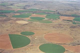 Centre pivot irrigation along the Lower Orange River. Source:Pyke 2008 ( click to enlarge ) |
![]()