|
Water Infrastructure: Dams and Infrastructure:
South Africa |
Upper Orange Water Management Area (WMA)
The Orange River Project (ORP) was launched in 1962 (publicised as "Taming a River Giant'') and aimed at promoting and stabilising irrigation along the Orange River and in the eastern Cape, as well as to generate hydro-power, supply water to towns and industries, and to limit flood damage (Conley and Van Niekerk 2000).
According to the Department of Water Affairs (DWA) South Africa, the Orange River Project was intended to increase the value of South African agricultural production and provide for a large number of irrigation farms. By promoting economic activity and development in the areas directly involved in the project, it was envisioned to counteract the migration of the rural population to the cities by creating stable farming communities. An additional objective of the project was to create recreation facilities in the centre of the interior and promote tourism. Finally, the project was intended to level off and moderate flood peaks in the course of the river, and so safeguard riparian communities and irrigation schemes downstream. Two main storage reservoirs were constructed: Gariep Dam and Vanderkloof Dam.
Gariep Dam
The Gariep Dam is the largest reservoir in South Africa with a total storage of approximately 5 500 Mm3 and a surface area of more than 370 km2 at full capacity (DWAF 2009). The Gariep dam supplies water to parts of the Vaal, Fish and Sundays River catchments, downstream releases to Vanderkloof Dam, and to irrigation schemes along the Orange River itself. Water from the Gariep Dam is transferred to the Fish and Sundays basins via the Orange/Fish Tunnel, at 82 km one of the longest continuous water transfer tunnels in the world.
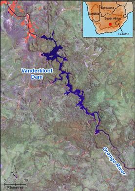
Vanderkloof Dam
Vanderkloof Dam is 130 km downstream of Gariep Dam on the Orange River. It is the second largest reservoir in South Africa, storing over than 3 200 Mm³. Water released from the Gariep Dam flows into Vanderkloof Dam, where it is either transferred through the Orange/Riet Canal to the Riet River basin or released downstream through two hydro-power generators.
Note: Areas of irrigated agriculture are shown as being pink on the satellite images.
Upper Vaal Water Management Area
The major impoundments in the Upper Vaal Water Management Area are the Vaal Dam, Grootdraai Dam, Sterkfontein Dam, Saulspoort Dam and the Vaal Barrage. The combined gross storage in these dams is 5 655 Mm³. There are also other small to medium dams in the catchment, mainly to supply water for local towns or irrigation.
Vaal Dam
The Vaal Dam is located on the Vaal River about 56 km south of Johannesburg. It is supplied the Vaal River and the Wilge River, which together drain a catchment area of about 38 500 km². At its maximum, the Vaal Dam can store 2 536 Mm3 with a surface area of approximately 320 km2, making it a relatively large and shallow reservoir.
The Vaal Dam is essentially the central storage reservoir for the Vaal River water supply system, which serves Gauteng province, the industrial hub of South Africa.
Rand Water, the major water utility in the Upper Vaal WMA, distributes water to the various demand centres through a network of pipelines. Water is abstracted at:
- Zuikerbosch pumping station, receiving water from the Vaal River via a canal from the Vaal Dam and from the Lethabo intake station
- Vereeniging pumping station; receiving water from the Vaal Barrage
Grootdraai Dam
Grootdraai Dam is situated in the upper reaches of the Vaal River. It has a catchment area of 8 195km2 and a maximum supply capacity of 364 Mm³. The dam was completed in 1982 and was built mainly to support the water needs of the SASOL I, II and III plants at Secunda, and various Eskom power stations.
Sterkfontein Dam
Sterkfontein Dam is located high the Vaal Dam catchment, a few kilometres from the edge of the Drakensberg Escarpment. It has a very small catchment area. The dam receives its water via the Tugela-Vaal Project which transfers up to 630 Mm3 of water annually from KwaZulu-Natal. Sterkfontein Dam stores this water and releases it to Vaal Dam via the Wilge River when needed. Due to the favourable storage and climatic characteristics of Sterkfontein Dam, it is beneficial to store water in the deep cool Sterkfontein Dam and only release water to the shallow Vaal Dam when needed to avoid loss from evaporation.
Middle Vaal Water Management Area
The major dams here are the Bloemhof, Erfenis, Allemanskraal, Koppies, Serfontein, Rietspruit, Elandskuil, Johan Neser, Klerkskraal, Boskop and Klipdrift Dams. These are mainly used for irrigation, although they also supply some urban/industrial and mining demands.
Bloemhof Dam
Bloemhof Dam is situated on the Vaal River, downstream of Vaal Dam, approximately 2 km upstream of the town of Bloemhof. The Dam was built in 1970 to help relieve Vaal Dam of the downstream load. Considerable quantities of water are exported beyond the boundaries of the Vaal River basin – to Pretoria, Rustenburg and the northern parts of Rand Water’s supply area, and to Eskom power stations.
At maximum supply, the capacity of Bloemhof Dam is 1 269 Mm3 with a surface area of 223 km2—a very large and shallow reservoir. The Dam was constructed to "detain" runoff originating below the Vaal Dam to meet the needs of users in the Lower Vaal River area. Water is also released from Bloemhof Dam to augment supplies to the Vaalharts Government Water Scheme where approximately 37 000 ha are under irrigation. The Vaalharts scheme is currently the largest user of water from Bloemhof Dam.
Two organisations, i.e. Midvaal Water Company and Sedibeng Water, abstract water from the Vaal River within the Middle Vaal WMA.
The Midvaal Water Company purifies water from the Vaal River to supply Klerksdorp, Stilfontein, and Orkney, and the Vaal Reefs, Hartbeesfontein and Buffelsfontein gold mines. Water is abstracted from the Vaal River through a pump station and diverted into two pipelines, one to the Vaal Reefs general mining, and the other to Klerksdorp, Stilfontein, Orkney, and the Hartbeesfontein and Buffelsfontein gold mines.
Sedibeng Water has a major abstraction point from the Vaal River at Balkfontein, upstream of Bloemhof Dam. Water is treated at the Balkfontein Water Purification Works and distributed from there.
Lower Vaal Water Management Area
The major dams in this WMA are Wentzel Dam, Taung Dam and Spitskop Dam, all located on the Harts River, with Vaalharts Weir on the Vaal River.
Lower Orange Water Management Area
The Gariep Dam and Vanderkloof Dam supply most of the water requirements in the Lower Orange WMA, although they are located in the Upper Orange WMA.
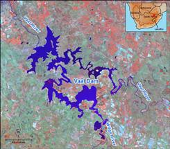 The Vaal Dam is located approximately 70 km south of Johannesburg. Source:Hatfield Consultants 2009 ( click to enlarge ) |
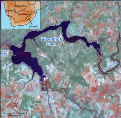 The Bloemhof Dam provides water to users in the Lower Vaal region. Source:Hatfield Consultants 2009 ( click to enlarge ) |
Note: Areas of irrigated agriculture are shown as being pink on the satellite images.
![]()